Search Results
Annexation of areas to city of Las Vegas, Nevada
Date
1921 to 1954
Archival Collection
Description
Series 2. Las Vegas Land and Water Company -- Walter Bracken and the Las Vegas, Nevada Office -- Water Company
Mixed Content
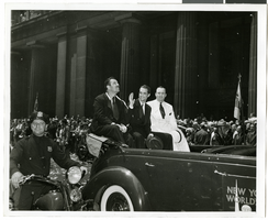
Photograph of a parade procession for Howard Hughes, New York, July 15, 1938
Date
1938-07-15
Archival Collection
Description
A view of Grover Whalen, Howard Hughes, and Al Lodwick riding in the back of an automobile during a parade procession. Description printed on back of photograph: "Howard Hughes welcomed at City Hall, New York. General scene. 7/15/38."
Image
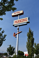
Rail City Casino mounted sign, Sparks, Nevada
Date
2020
Archival Collection
Description
View of the mounted sign directing people to the parking area for the Rail City Casino during the day with unlit neon.
2121 Victorian Ave, Sparks, NV 89431
Rail City Casino
Image
XF-11 plane before its first flight at the Hughes Airport in Culver City, California, 1946 July 03
Level of Description
File
Archival Collection
Howard Hughes Professional and Aeronautical Photographs
To request this item in person:
Collection Number: PH-00321
Collection Name: Howard Hughes Professional and Aeronautical Photographs
Box/Folder: Folder 07
Collection Name: Howard Hughes Professional and Aeronautical Photographs
Box/Folder: Folder 07
Archival Component

Map of California and territories of New Mexico and Utah, circa 1861
Date
1859 to 1862
Description
'Compiled, drawn, and engraved under the supervision of J.H. Colton and A.J. Johnson.' Relief shown by hachures and spot heights. Scale [ca. 1:3,041,280]. 1 in. to approx. 48 miles (W 124°--W 103°/N 42°--N 31°). Hand colored
Prime meridians: Greenwich and Washington
Plates 54 & 55 removed from Johnson's New illustrated family atlas of the world, with descriptions geographical, statistical and historical ... New York, 1862
Title page of atlas.
Prime meridians: Greenwich and Washington
Plates 54 & 55 removed from Johnson's New illustrated family atlas of the world, with descriptions geographical, statistical and historical ... New York, 1862
Title page of atlas.
Image
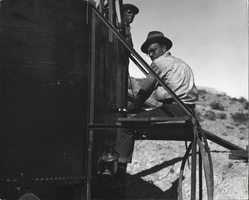
Photograph of construction for Boulder City, Nevada, March 1931
Date
1931-03
Archival Collection
Description
The grayscale view of two men working construction on a reservoir tank for Boulder City, Nevada.
Image
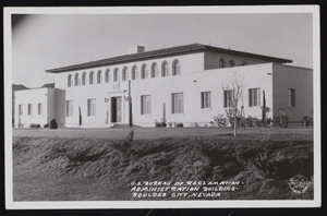
Postcard of a building, Boulder City (Nev.), 1934-1952
Date
1934 to 1952
Archival Collection
Description
Here is the Administration Building of U.S. Bureau of Reclamation located in Boulder City, Nevada.
Image
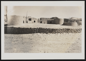
Photograph of a restored pueblo, Lost City (Nev.), 1934
Date
1934
Archival Collection
Description
Restored pueblo "used in pageant" in the Lost City ruins of Overton, Nevada.
Image
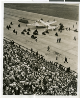
Photograph of Howard Hughes in New York, July 1938
Date
1938-07-14
Archival Collection
Description
A view of crowds waiting to see Howard Hughes arrive at Floyd Bennett Field in New York. Typed onto a piece of paper attached to the image: "Flight's End - Floyd Bennett Field, N.Y. -- Propellers still whirling, the plane which carried Howard Hughes and four companions on their dramatic Round-The-World flight, taxis to a stop, on a runway there, flanked by an escort of motorcycle policemen. Part of the crowd of 30,000 which was on hand to greet the fliers, may be seen. Credit Line (ACME) 7/14/38."
Image
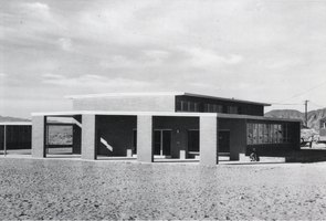
Photograph of the Administration building, Boulder City, Nevada, 1949
Date
1949
Archival Collection
Description
Black and white image of the exterior of Bureau of Reclamation building containing the Boulder City Junior-Senior High School.
Image