Search Results
Report: "Study of Betting on Sports in New York City" by the Fund for the City of New York Quayle Survey
Level of Description
File
Archival Collection
Eugene Martin Christiansen Papers
Archival Component
"The New York City Office of the Comptroller Discussion Materials Regarding New York City OTB", 2007
Level of Description
File
Archival Collection
Eugene Martin Christiansen Papers
Archival Component

Map of California and territories of New Mexico and Utah, circa 1861
Date
1856 to 1866
Description
40 x 60 cm. Relief shown by hachures and spot heights. Prime meridians: Greenwich and Washington. Atlas plate numbers 54 and 55 in the upper corners. Shows forts, trails, exploration routes, drainage, mail steamship routes, physical features, Indian tribes, and historic sites. The geographic region of Southwest is referred to as the New Southwest. Original publisher: Johnson .
Image


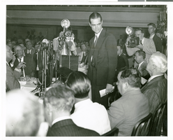
Photograph of Howard Hughes speaking at the National Press Club, New York City, July 15, 1938
Date
1938-07-15
Archival Collection
Description
Typed onto a piece of paper attached to the image: "Howard Hughes and his four companions honored at the National Press Club. Howard Hughes is speaking, with Mayor La Guardia and Secretary of State Cordell Hull at lower right. July 1938."
Image
New York City Center, undated
Level of Description
File
Archival Collection
JMA Architecture Studio Records
Archival Component
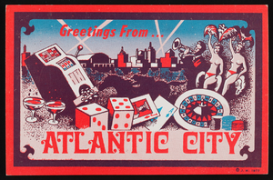
Atlantic City, New Jersey: postcard
Date
1940 (year approximate) to 1990 (year approximate)
Archival Collection
Description
From Harvey's Hotel and Casino Postcard Collection (PH-00367)
Image
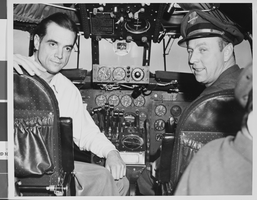
Photograph of Howard Hughes in cockpit, New York, February 15, 1946
Date
1946-02-15
Archival Collection
Description
Description given with photo: "Non-Stop Los Angeles - New York Flight Inaugurated New York -- Howard Hughes, pilot, and Joseph Bartles (right), relief pilot, at the controls of the TWA Constellation which inaugurated non-stop Los Angeles - New York flights when the ship landed at LaGuardia Airport Feb. 15. Hughes, famous flier and TWA executive, was at the controls during the flight made in 8 hours, 38 minutes. Many Hollywood luminaries made the first flight. Credit (ACME). 2-15-46."
Image
Daily Breakthrough (New York City, New York), 1977 November
Level of Description
File
Archival Collection
Jean Ford Papers
Archival Component