Search Results
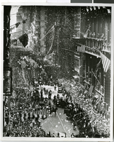
Photograph of Howard Hughes and his crew at a parade, New York, July 15, 1938
Date
1938-07-15
Archival Collection
Description
The black and white view of Howard Hughes and his crew at a parade after he completed his Round-The-World flight in New York. Handwritten on the back of the image: "B' way parade temporarily blocked by fire engines answering false alarm. 7/15/38."
Image

Map of California, and territories of Utah, Nevada, Colorado, New Mexico and Arizona, 1864
Date
1864
Description
'Johnson's California, also Utah, Nevada, Colorado, New Mexico, and Arizona, published by A.J. Johnson, New York.' 'Entered according to act of Congress in the year 1864, by A.J. Johnson in the Clerks Office of the District Court of the United States for the southern district of New York.' Atlas page numbers in upper margin: 67-68. Relief shown by hachures. Prime meridian: Greenwich and Washington. Shows natural features, locations of Indian tribes, proposed railroad routes, routes of explorers, trails, county boundaries and populated places. Hand colored. On verso: 'Historical and statistical view of the West India Islands or Columbian Archipelago' (p. 80) and 'Historical and statistical view of Mexico and Central America' (p. 79). Scale [ca. 1:3,484,800]. 1 in. to ca. 55 miles (W 124°--W 102°/N 42°--N 32°).
Text
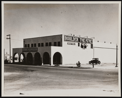
Photograph of a theater, Boulder City (Nev.), September 15, 1932
Date
1932-09-15
Archival Collection
Description
The photograph taken by B.D. Glaha September 15, 1932 of the Boulder Theater in Boulder City, Nevada. The marquee reads: American Madness with Walter Huston, Kay Johnson, also Igloo, a thrilling adventure of the Frozen Arctic.
Image
Howard Hughes at the microphone, during his brief address at welcoming ceremonies in the Council Chamber at City Hall, New York, 1938 July 15
Level of Description
File
Archival Collection
Howard Hughes Public Relations Photograph Collection
Archival Component
Restaurant in the Showboat Casino, Atlantic City, New Jersey, 1986
Level of Description
Item
Archival Collection
Showboat Atlantic City Photograph Collection
Archival Component
Gamblers in the Showboat Casino, Atlantic City, New Jersey, 1986
Level of Description
Item
Archival Collection
Showboat Atlantic City Photograph Collection
Archival Component

Map of California, Utah, Nevada, Colorado, New Mexico and Arizona, circa 1867
Date
1865 to 1869
Description
39 x 56 cm. Relief shown by hachures. "Entered according to act of Congress in the year 1864, by A.J. Johnson in the Clerks Office of the United States for the Southern District of New York." Atlas page numbers in upper margin: 67-68. Primer meridians: Greenwich and Washington, D.C. On verso: History and statistical view of the West India islands or Columbian Archipelago and Historical and statistical view of Mexico and Central America. Shows proposed railroads, locations of Indian tribes, natural features, counties, mines, mail routes, trails and routes of exploring expeditions. Has decorative border. Southern part of Nevada was added to the state in 1867 and is part of Nevada on this map, but Lincoln County was established in 1867 and is not on this map. This map was still probably published in 1867 in spite of someone's having written "1864" in pencil in the lower right corner of the Library's copy. Original publisher: A.J. Johnson.
Image
Wilbur and Toni Clark at a formal dinner at the Hotel Astor in New York City, New York, 1958
Level of Description
File
Archival Collection
Toni and Wilbur Clark Photographs
Archival Component
Del Webb's Sahara Boardwalk-Atlantic City, New Jersey
Level of Description
File
Archival Collection
Martin Stern Architectural Records
Archival Component
Harrah's Marina Hotel Casino: Atlantic City, New Jersey
Level of Description
Series
Archival Collection
Martin Stern Architectural Records
Archival Component