Search the Special Collections and Archives Portal
Search Results
New York New York, press clippings, 1995-2000
Level of Description
Archival Collection
Collection Name: MGM Mirage Records on Mandalay Resort Group
Box/Folder: Box 27
Archival Component
New York, New York Hotel and Casino, 1997 to 2006
Level of Description
Archival Collection
Collection Name: UNLV Libraries Collection of Gaming Industry Promotional Materials and Reports
Box/Folder: Box 05
Archival Component
Howard Hughes in New York, New York, 1946 September
Level of Description
Archival Collection
Collection Name: Howard Hughes Public Relations Photograph Collection
Box/Folder: Folder 23
Archival Component
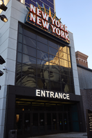
New York New York entrance to "The Park," Las Vegas, Nevada: digital photograph
Date
Archival Collection
Description
Image

New York New York entrance to "The Park," Las Vegas, Nevada: digital photograph
Date
Archival Collection
Description
Image
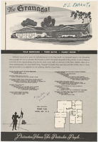
Sales material for the Granada model home in the El Encanto development, Las Vegas, Nevada, 1967-1969
Date
Archival Collection
Description
Sales material from the late 1960s for model no. 15 A residential home, called "The Granada," in the El Encanto development, Las Vegas, Nevada. One side has an illustration of the front exterior elevation, a floor plan, and a list of features. The other side shows two alternate exterior elevation illustrations (15A-3-L and 15A-1-R). The price is handwritten. The development is located between Harmon and Tropicana Avenues (north and south) and Sandhill Rd. (west) and S. Lamb Blvd. (east).
Site Name: El Encanto (Las Vegas, Nevada)
Text
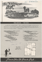
Sales material for the Valencia model home in the El Encanto development, Las Vegas, Nevada, 1967-1969
Date
Archival Collection
Description
Sales material from the late 1960s for model no. 15 B residential home, called "The Valencia," in the El Encanto development, Las Vegas, Nevada. One side has an illustration of the front exterior elevation, a floor plan, and a list of features. The other side shows two alternate exterior elevation illustrations (15B-3-R and 15B-2-R). The price is handwritten. The development is located between Harmon and Tropicana Avenues (north and south) and Sandhill Rd. (west) and S. Lamb Blvd. (east).
Site Name: El Encanto (Las Vegas, Nevada)
Text
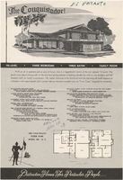
Sales material for the Conquistador model home in the El Encanto development, Las Vegas, Nevada, 1967-1969
Date
Archival Collection
Description
Sales material from the late 1960s for model no. 15 C residential home called "The Conquistador," in the El Encanto development, Las Vegas, Nevada. One side has an illustration of the front exterior elevation, a floor plan, and a list of features. The other side shows two alternate exterior elevation illustrations (15C-1-L and 15C-2-R). The price is handwritten. The development is located between Harmon and Tropicana Avenues (north and south) and Sandhill Rd. (west) and S. Lamb Blvd. (east).
Site Name: El Encanto (Las Vegas, Nevada)
Text
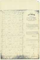
Plat of H.F.M & M addition to city of Las Vegas, Clark County, Nevada, comprising the west 1/2 of N.W. 1/4 Sec. 27, Twp. 20 S., R. 61 E., M.D.B & M, March 8, 1924
Date
Description
Image

