Search Results
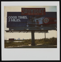
Polaroid of Showboat billboard advertisement, Atlantic City, New Jersey: photographic print
Date
1986
Archival Collection
Description
From the Showboat Atlantic City Photograph Collection (PH-00329).
Image
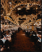
Interior view of Showboat Casino, Atlantic City, New Jersey: photographic print
Date
1986
Archival Collection
Description
From the Showboat Atlantic City Photograph Collection (PH-00329).
Image
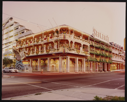
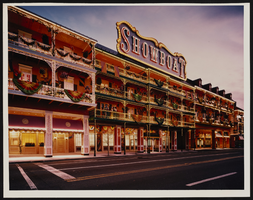
Exterior view of the Showboat Casino, Atlantic City, New Jersey: photographic print
Date
1986
Archival Collection
Description
From the Showboat Atlantic City Photograph Collection (PH-00329).
Image
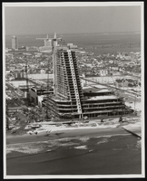
Construction of the Showboat high-rise, Atlantic City, New Jersey: photographic print
Date
1986
Archival Collection
Description
From the Showboat Atlantic City Photograph Collection (PH-00329).
Image
Exterior view of Showboat Casino, Atlantic City, New Jersey: photographic print
Date
1986
Archival Collection
Description
From the Showboat Atlantic City Photograph Collection (PH-00329).
Image
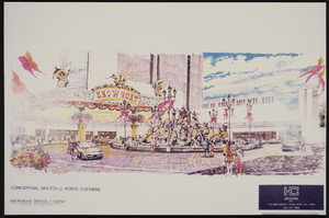
Conceptual sketch of the porte cochere at the Showboat Casino, Atlantic City, New Jersey
Date
1986
Archival Collection
Description
From the Showboat Atlantic City Photograph Collection (PH-00329).
Image

Map of California, Nevada, Utah, Colorado, Arizona & New Mexico, circa 1867
Date
1865 to 1869
Description
39 x 62 cm. Relief shown by hachures and spot heights. Prime meridian: Greenwich and Washington. Hand colored. Shows natural features, populated places, routes of mail steamships, routes of explorers, locations of Indian tribes, railroad routes, and proposed railroad routes. In top margin: No. 80-81. On verso: New Mexico, Arizona, Colorado, Idaho, Dakota (statistics and other information) and The state of California (statistics and other information). Original publisher: G.W. and C.B. Colton.
Image
City Lights, Atlantic City, New Jersey video recording, approximately 1960 to 2009
Level of Description
File
Archival Collection
Bill Moore Professional Papers
Archival Component
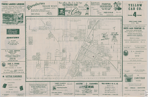
Street map of the city of Las Vegas, 1954
Date
1954
Description
22 x 34 cm. on sheet 36 x 54 cm. Copyright held by Redwood Publishing Co. Includes advertisements. 1954 [ed.] Street index, map of the Strip and advertisements on verso. Map is irregularly shaped. Original publisher: Redwood Pub. Co..
Image

Map of California, and territories of Utah, Nevada, Colorado, New Mexico and Arizona, 1864
Date
1864
Description
'Johnson's California, also Utah, Nevada, Colorado, New Mexico, and Arizona, published by A.J. Johnson, New York.' 'Entered according to act of Congress in the year 1864, by A.J. Johnson in the Clerks Office of the District Court of the United States for the southern district of New York.' Atlas page numbers in upper margin: 67-68. Relief shown by hachures. Prime meridian: Greenwich and Washington. Shows natural features, locations of Indian tribes, proposed railroad routes, routes of explorers, trails, county boundaries and populated places. Hand colored. On verso: 'Historical and statistical view of the West India Islands or Columbian Archipelago' (p. 80) and 'Historical and statistical view of Mexico and Central America' (p. 79). Scale [ca. 1:3,484,800]. 1 in. to ca. 55 miles (W 124°--W 102°/N 42°--N 32°).
Text