Search Results

Map of California, Utah, Nevada, Colorado, New Mexico and Arizona, circa 1867
Date
1865 to 1869
Description
39 x 56 cm. Relief shown by hachures. "Entered according to act of Congress in the year 1864, by A.J. Johnson in the Clerks Office of the United States for the Southern District of New York." Atlas page numbers in upper margin: 67-68. Primer meridians: Greenwich and Washington, D.C. On verso: History and statistical view of the West India islands or Columbian Archipelago and Historical and statistical view of Mexico and Central America. Shows proposed railroads, locations of Indian tribes, natural features, counties, mines, mail routes, trails and routes of exploring expeditions. Has decorative border. Southern part of Nevada was added to the state in 1867 and is part of Nevada on this map, but Lincoln County was established in 1867 and is not on this map. This map was still probably published in 1867 in spite of someone's having written "1864" in pencil in the lower right corner of the Library's copy. Original publisher: A.J. Johnson.
Image

Photograph of Howard Hughes and crew posing for photographs outside of City Hall, New York City, July 15, 1938
Date
1938-07-15
Archival Collection
Description
Typed onto a piece of paper attached to the image: "Howard Hughes reception at City Hall - 7/15/38. (Press Association)."
Image

Photograph of Howard Hughes and Grover Whalen, New York City, July 15, 1938
Date
1938-07-15
Archival Collection
Description
The black and white view of Grover Whalen (left) and Howard Hughes (right) enjoying the attention from a crowd of thousands of people who attended a parade that celebrated Hughes' completion of his Round the World flight in New York City.
Image
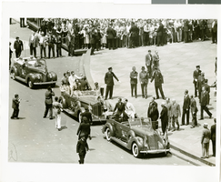
Photograph of a parade for Howard Hughes, New York City, July 15, 1938
Date
1938-07-15
Archival Collection
Description
Typed onto a piece of paper attached to the image: "Howard Hughes and his crew arriving at the City Hall after their Round-The-World flight. July 1938."
Image
Photographs of Harrah's property: Sky City (Auckland, New Zealand), undated
Level of Description
File
Archival Collection
Harrah’s Entertainment Corporate Archives
Archival Component

Plan of proposed new well pipe and fittings for Las Vegas, Nevada, 1936
Date
1936
Archival Collection
Description
Blueprint. Written on back of map:: 'Purposed [sic] new transmission lines--1936--transits.' Las Vegas Land and Water Company?
Image
New Zealand, "Sky City Limited, Annual Report 1997", 1997
Level of Description
File
Archival Collection
Peter Collins Papers on International Gaming
Archival Component
Sands (Atlantic City, New Jersey) news reports, 1990-2002
Level of Description
File
Archival Collection
Eugene Martin Christiansen Papers
Archival Component
Hayes, Frederick O. R., "The Prospects for Casino Gambling in New York City", 1979
Level of Description
File
Archival Collection
Eugene Martin Christiansen Papers
Archival Component
Report: "A New Day Dawning in Atlantic City" by Bear Stearns, 2002
Level of Description
File
Archival Collection
Eugene Martin Christiansen Papers
Archival Component