Search Results
Harrah's Trump Plaza Hotel and Casino: Atlantic City, New Jersey, 1982 August 2
Level of Description
Series
Archival Collection
Martin Stern Architectural Records
To request this item in person:
Collection Number: MS-00382
Collection Name: Martin Stern Architectural Records
Box/Folder: N/A
Collection Name: Martin Stern Architectural Records
Box/Folder: N/A
Archival Component
Trump Plaza Hotel and Casino: Atlantic City, New Jersey, 1982 January 22
Level of Description
Series
Archival Collection
Martin Stern Architectural Records
To request this item in person:
Collection Number: MS-00382
Collection Name: Martin Stern Architectural Records
Box/Folder: N/A
Collection Name: Martin Stern Architectural Records
Box/Folder: N/A
Archival Component
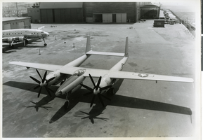
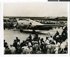
Photograph of the XF-11 prior to its first test flight in Culver City, California July 7, 1947
Date
1947
Archival Collection
Description
Transcribed from press release attached to back of photo: "NEW-DESIGN PHOTO PLANE COMPLETED CULVER CITY, Calif., July 7 -- test-flown today for the first time, the new XF-11 was revealed as one of the world's fastest long-range photographic planes. It was designed and built by Howard Hughes in conjunction with the Air Materiel command engineers. Army officials said that it can attain a speed of more than 400 miles per hour and a ceiling of more than 40,000 feet. The plane has a pressurized cabin making it unnecessary for the crew to use oxygen masks. Outstanding features include a full-span flap, unique eight-camera layout and exceptionally fast take-off." Transcribed from photo sleeve: "Howard Hughes sits in the cockpit of the XF-11, a reconnaissance plane that Hughes built and designed in conjunction with Air Materiel Command engineers. Hughes is preparing for his first test flight in Culver City, California July 7, 1947."
Image
Annual Report; Fiscal Year July 1, 1973 to June 30, 1974 by City of Boulder City, Nevada (Clark Co. Health), 1973 July 01 to 1974 June 30
Level of Description
File
Archival Collection
Clark County Planning Commission Research Library Collection
To request this item in person:
Collection Number: MS-01027
Collection Name: Clark County Planning Commission Research Library Collection
Box/Folder: Box 86
Collection Name: Clark County Planning Commission Research Library Collection
Box/Folder: Box 86
Archival Component

Photograph of the landing of Howard Hughes' Lockheed 14 aircraft, New York, July 14, 1938
Date
1938-07-14
Archival Collection
Description
The black and white view of Howard Hughes' Lockheed 14 aircraft performing its final landing on the Round the World flight at Floyd Bennett Airport, New York. Typed onto a piece of paper attached to the image: "Howard Hughes lands at Floyd Bennett Field. 7/38."
Image
Photograph of the landing of Howard Hughes' Lockheed 14 aircraft, New York, July 14, 1938
Date
1938-07-14
Archival Collection
Description
The black and white view of Howard Hughes' Lockheed 14 aircraft performing its final landing on the Round the World flight at Floyd Bennett Airport, New York. Typed onto a piece of paper attached to the image: "Howard Hughes taxiing up runway at Floyd Bennett Airport."
Image
Photograph of the landing of Howard Hughes' Lockheed 14 aircraft, New York, July 14, 1938
Date
1938-07-14
Archival Collection
Description
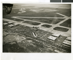
The black and white, aerial view of Howard Hughes' Lockheed 14 aircraft performing its final landing on the Round the World flight at Floyd Bennett Airport, New York. Typed onto a piece of paper attached to the image: "Journey's End: This airplane view records the end of Howard Hughes' history-making dash around the world in three days, nineteen hours. To the right of the Administration Building at Floyd Bennett Field, Long Island, New York, can be seen the globe-girdling monoplane surrounded by a ring of policemen. The foreground provides an accurate idea of the size of the crowd which stormed the field to welcome home the fliers. Credit Line (ACME)."
Image