Search Results
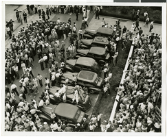
Photograph of crowds at Floyd Bennett Airfield, New York, July 1938
Date
1938-07-14
Archival Collection
Description
The black and white, overhead view of Howard Hughes and his crew after completing his Around the World flight at Floyd Bennett Airport, New York. Description printed on photograph's accompanying sheet of paper: "On hand to welcome Hughes and his gallant crew New York City-- Looking down on a segment of the huge crowd that gathered at Floyd Bennett Field, July 14th, to greet the arrival of Howard Hughes and his picked crew of four at the end of their record-smashing flight around the world. The tops of the cars jamming the parking spaces were used as coigns of vantage. Credit Line (ACME) 7/14/38 (SS)"
Image
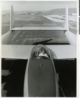
Photograph of Howard Hughes sitting in the cockpit of the XF-11 preparing for his first test flight in Culver City, California July 7, 1947
Date
1947
Archival Collection
Description
Transcribed from press release attached to back of photo: "NEW PHOTO PLANE TEST-FLOWN CULVER CITY, California, July 7 -- Howard Hughes, who designed and built the new FX-11 reconnaissance plane in conjunction with Air Materiel Command engineers, sits in the pilot's bubble-glass canopy preparing for the first test flight. One of the world's fastest long-range photo planes, the XF-11 can attain a speed of more than 400 miles per hour, Army officials said. It is powered by two 3000-horsepower radial engines with eight-bladed contra-rotating propellers. Outstanding features include a full-span flap, unique eight-camera layout, and exceptionally fast take-off." Transcribed from photo sleeve: "Howard Hughes sits in the cockpit of the XF-11, a reconnaissance plane that Hughes built and designed in conjunction with Air Materiel Command engineers. Hughes is preparing for his first test flight in Culver City, California July 7, 1947.
Image

Photograph of Boulder City, Nevada, March 28, 1937
Date
1937-03-28
Archival Collection
Description
The grayscale, aerial view of Boulder City, Nevada. The prominent road of Nevada Way can be seen passing through the little town with the great reservoir of Lake Mead residing in the background. Bits of the actual plane from which the photo was taken can be seen alongside the right border of the image.
Image
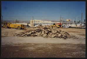
Breaking ground on the construction of the new union hall on Commerce Street, Culinary Union, Las Vegas (Nev.), 1990s (folder 1 of 1), image 15
Date
1990 to 1999
Description
Arrangement note: Series III. Internal: Work
Image


Cadastral map of Boulder City, Nevada, 1940
Date
1905-04-23
Description
A. M. S. Jan. 1940 in the lower left-hand corner. 1 map ; 61 x 30 cm. Cadastral map. "No. 40-1" in the lower right-hand corner. Shows block and lot numbers, buildings, water supply and sewage system, leased areas.
Image
