Search Results

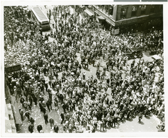
Photograph of a parade for Howard Hughes, New York City, July 15, 1938
Date
1938-07-15
Archival Collection
Description
The view of a crowd consisting of thousands of people who attended a parade that celebrated Howard Hughes completion of his flight Around the World in New York City.
Image
Photograph of a parade for Howard Hughes, New York City, July 15, 1938
Date
1938-07-15
Archival Collection
Description
The view of a crowd consisting of thousands of people who attended a parade that celebrated Howard Hughes completion of his flight Around the World in New York City.
Image

Map of California, Utah, Nevada, Colorado, New Mexico and Arizona, 1864
Date
1864
Description
'Johnson's California, with Utah, Nevada, Colorado, New Mexico, and Arizona, published by Johnson and Ward.' 'Entered according to Act of Congress in the Year 1864 by A.J. Johnson in the Clerks Office of the District Court of the United States for the southern district of New York.' Atlas page numbers in upper margin: 66-67. This is probably plate 67 from Johnson's New Illustrated Family Atlas, published in New York by Johnson & Ward in 1864. Shows natural features, locations of Indian tribes, proposed railroad routes, routes of explorers, trails, county boundaries and populated places ; "." ; Relief shown by hachures ; Prime meridians: Greenwich and Washington ; In top margin: 66-67 ; Hand colored ; On verso: Historical and statistical view of Mexico and central America (p. 79) and Historical and statistical view of the United States, 1860 (p. 78) Scale [ca. 1:3,484,800]. 1 in. to ca. 55 miles (W 124°--W 102°/N 42°--N 32°)
Text
Report: "Marketing Casino Gambling and a Local Lottery in New York City" by the Council of the City of New York for the Committee on Economic Development, 1991
Level of Description
File
Archival Collection
Eugene Martin Christiansen Papers
Archival Component

City map of Las Vegas, 1973
Date
1905-05-26
Description
Color; 55 x 45 cm., on sheet 95 x 47 cm., folded to 24 x 10 cm. Panel title: Las Vegas city map. Copyright held by Cardinal Publishing Company. Relief shown by hachures. Includes illustrations and advertisements. Index, text, illustrations, advertisements, and map of "Lake Mead National Recreation Area, lower basin section" on verso. Original publisher: Cardinal Publishing Company.
Image

Map of the territories of New Mexico, Arizona, Colorado, Nevada, and Utah, 1855
Date
1855
Description
29 x 36 cm. Relief shown by hachures. Prime meridians: Greenwich and Washington. "Entered according to act of Congress in the year 1855 by J.H. Colton & Co. in the Clerk's Office of the Dist. Office of the U.S. for the Southern. Dist. of New York." Hand colored. Decorative border. Atlas p. number in lower-right margin: 67. Shows routes of explorers, proposed railroad routes, wagon route, mail route, Indian reserves and mines. On verso: History and statistical view of Mexico. Original publisher: J.H. Colton.
Image
Atlantic City Convention Hall: postcards and opening day booklet, 1928
Level of Description
File
Archival Collection
Sonny Schwartz Recordings and Papers
Archival Component
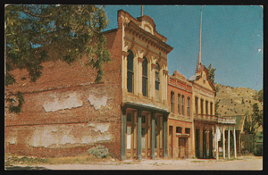
Knights of Pythias and the Miners' Union Hall, Virginia City, Nevada: postcard
Date
1975 (year approximate)
Description
From the Nan Doughty Photograph Collection (PH-00240)
Image
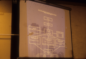
Slide presentation from a hearing at a City Hall in Nevada: photographic slide
Date
1979-05
Archival Collection
Description
From the Sister Klaryta Antoszewska Photograph Collection (PH-00352). The presentation slide reads, "Off-site radiation exposure review project organization chart"
Image
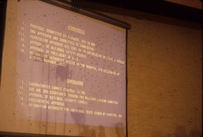
Slide presentation from a hearing at a City Hall in Nevada: photographic slide
Date
1979-05
Archival Collection
Description
From the Sister Klaryta Antoszewska Photograph Collection (PH-00352). The presentation slide lists the steps required to conduct atmospheric and underground bomb tests.
Image