Search Results
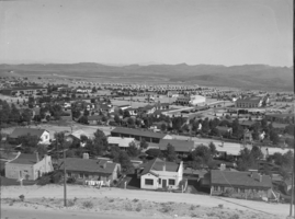
Film transparency showing streets of Boulder City, Nevada, circa 1933-1940s
Date
1933 to 1949
Archival Collection
Description
A view of buildings in Boulder City, Nevada; the Boulder Theatre as well as the Boulder Cafe and neighboring souvenir and flower shops an be seen in the background.
Image
Las Vegas City budget for the year, 1926
Level of Description
File
Archival Collection
Las Vegas City Commission Records
To request this item in person:
Collection Number: MS-00237
Collection Name: Las Vegas City Commission Records
Box/Folder: Box 01
Collection Name: Las Vegas City Commission Records
Box/Folder: Box 01
Archival Component
Resolution Ordering General City Election, 1941
Level of Description
File
Archival Collection
Las Vegas City Commission Records
To request this item in person:
Collection Number: MS-00237
Collection Name: Las Vegas City Commission Records
Box/Folder: Box 01
Collection Name: Las Vegas City Commission Records
Box/Folder: Box 01
Archival Component
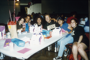
Slide of students at a National Residence Hall Honorary event, University of Nevada, Las Vegas, circa 1990s
Date
1990 to 1999
Archival Collection
Description
UNLV students at an NRHH event.
Image
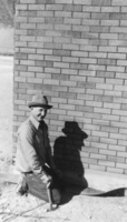
Gerald Miller Carver working on the northeast corner of the dance hall, Carver's Station, Nevada: photographic print
Date
1950
Archival Collection
Description
From the Nye County, Nevada Photograph Collection (PH-00221) -- Series V. Smoky Valley, Nevada and Round Mountain, Nevada -- Subseries V.A. Carver, Carver-Duhme, and Carver-Book Families (Smoky Valley)
Image