Search the Special Collections and Archives Portal
Search Results
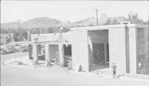
Film transparency of a general view of Boulder City, Nevada, circa 1930s-1940s
Date
1930 to 1949
Archival Collection
Description
On a sunny day in the desert, unnamed construction men work on a building that will later be the Visitors Bureau located on Arizona Street in Boulder City, Nevada.
Image

Film transparency of a general view of Boulder City, Nevada, circa 1930s-1940s
Date
1930 to 1949
Archival Collection
Description
On a sunny day in the desert, unnamed construction men work on a building that will later be the Visitors Bureau located on Arizona Street in Boulder City, Nevada.
Image
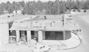
Film transparency of a general view of Boulder City, Nevada, circa 1930s-1940s
Date
1930 to 1949
Archival Collection
Description
On a sunny day in the desert, unnamed construction men work on a building that will later be the Visitors Bureau located on Arizona Street in Boulder City, Nevada.
Image
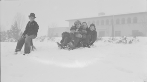
Film transparency of a general view of Boulder City, Nevada, circa 1930s-1940s
Date
1930 to 1949
Archival Collection
Description
The view of unidentified children playing in the snow with their snowboard in front of the Bureau of Reclamation Building located at 1200 Park Street Boulder City, Nevada.
Image

Film transparency showing street in Boulder City, Nevada, circa 1931-1940s
Date
1931 to 1949
Archival Collection
Description
An image of a street in Boulder City; a Texaco gas station, a hardware store, a cafe, a drug store, an several other business establishments are pictured.
Image
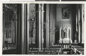
Postcard of St. Mary's Church interior, Virginia City, Nevada, 1868 - late 1800s
Date
1868 to 1899
Archival Collection
Description
A view of the interior of St. Mary's Church in Virginia City, Nevada. The text printed on the front of the postcard reads: "St. Mary's in the mountains, built 1868 - burned 1875, rebuilt 1876, Virginia City, Nevada." Site Name: St. Mary's Church (Virginia City, Nev.)
Image
Pagination
Refine my results
Content Type
Creator or Contributor
Subject
Archival Collection
Digital Project
Resource Type
Year
Material Type
Place
Language
Records Classification

