Search Results
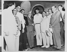
Photograph of Howard Hughes and others, Los Angeles, 1938
Date
Archival Collection
Description
Image
Photograph of Howard Hughes and others, Los Angeles, 1938
Date
Archival Collection
Description
Image
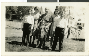
Photograph of Ella Wengert with grandchildren, April 17, 1938
Date
Archival Collection
Description
Standing from left to right is Robert Wengert, Marilyn Wengert Gatewood, Shirley Wengert, Ella Wengert, an unidentified family cousin, and Ward Wengert posing together on Easter.
Image
Las Vegas City Engineering and Planning Department Reports
Identifier
Abstract
The Las Vegas City Engineering and Planning Department Reports (1951-1981) consist of urban planning reports, transportation and parking studies, and environmental impact assessments concerning the greater Las Vegas, Nevada metropolitan area. In addition to general issues of urban planning, the collection contains materials relating to the expansion of Interstate 15 through West Las Vegas in the 1970s and early 1980s.
Archival Collection
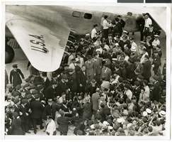
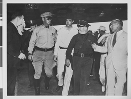
Photograph of crowds at Floyd Bennett Airfield, New York, July 1938
Date
Archival Collection
Description
Image

Letter from Walter R. Bracken (Las Vegas) to Mr. Will Wittwer (Las Vegas Ranch), May 5, 1938
Date
Archival Collection
Description
Responding to complaints that water from a spring located on the Las Vegas ranch property had been contaminated, directions were given to repair and protect the spring.
Text
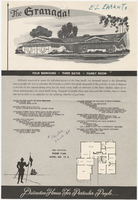
Sales material for the Granada model home in the El Encanto development, Las Vegas, Nevada, 1967-1969
Date
Archival Collection
Description
Sales material from the late 1960s for model no. 15 A residential home, called "The Granada," in the El Encanto development, Las Vegas, Nevada. One side has an illustration of the front exterior elevation, a floor plan, and a list of features. The other side shows two alternate exterior elevation illustrations (15A-3-L and 15A-1-R). The price is handwritten. The development is located between Harmon and Tropicana Avenues (north and south) and Sandhill Rd. (west) and S. Lamb Blvd. (east).
Site Name: El Encanto (Las Vegas, Nevada)
Text
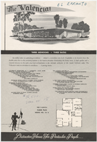
Sales material for the Valencia model home in the El Encanto development, Las Vegas, Nevada, 1967-1969
Date
Archival Collection
Description
Sales material from the late 1960s for model no. 15 B residential home, called "The Valencia," in the El Encanto development, Las Vegas, Nevada. One side has an illustration of the front exterior elevation, a floor plan, and a list of features. The other side shows two alternate exterior elevation illustrations (15B-3-R and 15B-2-R). The price is handwritten. The development is located between Harmon and Tropicana Avenues (north and south) and Sandhill Rd. (west) and S. Lamb Blvd. (east).
Site Name: El Encanto (Las Vegas, Nevada)
Text