Search Results
Sun City MacDonald Ranch as seen from the City View Trail, Henderson, Nevada, 2016 September 14
Level of Description
File
Archival Collection
UNLV University Libraries Photographs of the Development of the Las Vegas Valley, Nevada
To request this item in person:
Collection Number: PH-00394
Collection Name: UNLV University Libraries Photographs of the Development of the Las Vegas Valley, Nevada
Box/Folder: N/A
Collection Name: UNLV University Libraries Photographs of the Development of the Las Vegas Valley, Nevada
Box/Folder: N/A
Archival Component
Children dressed up in costumes, possibly for the 4th of July at City Hall in Boulder City, Nevada, undated
Level of Description
File
Archival Collection
L. F. Manis Photograph Collection
To request this item in person:
Collection Number: PH-00100
Collection Name: L. F. Manis Photograph Collection
Box/Folder: Folder 67
Collection Name: L. F. Manis Photograph Collection
Box/Folder: Folder 67
Archival Component
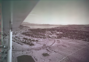
Film transparency of Boulder City, Nevada, and Lake Mead, circa 1931-1936
Date
1931 to 1936
Archival Collection
Description
An image showing an aerial view of Boulder City. The outlines of the small city are distinctively marked by the stark contrast between the city's greenery and the surrounding desert. In the far distance, the shores of Lake Mead can be seen peaking out from behind the mountains. Note: Bits of the airplane from which the image itself was taken can be seen in the upper right corner of the photograph.
Image