Search Results
City Center brochures, 2006
Level of Description
File
Archival Collection
MGM Mirage Corporation Records
To request this item in person:
Collection Number: MS-00096
Collection Name: MGM Mirage Corporation Records
Box/Folder: Box 14, Box 16
Collection Name: MGM Mirage Corporation Records
Box/Folder: Box 14, Box 16
Archival Component
City Hall, 1961-1981
Level of Description
File
Archival Collection
North Las Vegas Library District Collection on Nevada
To request this item in person:
Collection Number: MS-00651
Collection Name: North Las Vegas Library District Collection on Nevada
Box/Folder: Box 12, Box 13
Collection Name: North Las Vegas Library District Collection on Nevada
Box/Folder: Box 12, Box 13
Archival Component
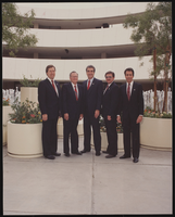
Photograph of the City Council, Las Vegas (Nev.), 1987
Date
1987
Archival Collection
Description
1987 City Council from left to right is Arnie Adamsen, Wayne Bunker, Mayor Ron Lurie, Bob Nolen, and Steve Miller.
Image
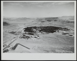
View of Boulder City, Nevada looking northeast: photographic print
Date
1950 (year uncertain; year approximate) to 1955 (year uncertain; year approximate)
Archival Collection
Description
From the Morgan Sweeney Photograph Collection (PH-00228). Aerial View of Boulder City, Nevada, looking northeast, 1950-55(?).
Image
Boulder City, 1933-1934
Level of Description
File
Archival Collection
Elbert Edwards Photograph Collection
To request this item in person:
Collection Number: PH-00214
Collection Name: Elbert Edwards Photograph Collection
Box/Folder: Folder 22
Collection Name: Elbert Edwards Photograph Collection
Box/Folder: Folder 22
Archival Component
Lost City, 1938-1939
Level of Description
File
Archival Collection
Elbert Edwards Photograph Collection
To request this item in person:
Collection Number: PH-00214
Collection Name: Elbert Edwards Photograph Collection
Box/Folder: Folder 06
Collection Name: Elbert Edwards Photograph Collection
Box/Folder: Folder 06
Archival Component
Bad City Detours, 2004
Level of Description
File
Archival Collection
Guide to the Canadian Film Centre Worldwide Short Film Festival Submissions
To request this item in person:
Collection Number: MS-00615
Collection Name: Guide to the Canadian Film Centre Worldwide Short Film Festival Submissions
Box/Folder: Box 2005-014
Collection Name: Guide to the Canadian Film Centre Worldwide Short Film Festival Submissions
Box/Folder: Box 2005-014
Archival Component
City Stories - 1912, 2005
Level of Description
File
Archival Collection
Guide to the Canadian Film Centre Worldwide Short Film Festival Submissions
To request this item in person:
Collection Number: MS-00615
Collection Name: Guide to the Canadian Film Centre Worldwide Short Film Festival Submissions
Box/Folder: Box 2005-020
Collection Name: Guide to the Canadian Film Centre Worldwide Short Film Festival Submissions
Box/Folder: Box 2005-020
Archival Component
River City Devil, 2005
Level of Description
File
Archival Collection
Guide to the Canadian Film Centre Worldwide Short Film Festival Submissions
To request this item in person:
Collection Number: MS-00615
Collection Name: Guide to the Canadian Film Centre Worldwide Short Film Festival Submissions
Box/Folder: Box 2005-025
Collection Name: Guide to the Canadian Film Centre Worldwide Short Film Festival Submissions
Box/Folder: Box 2005-025
Archival Component
5 to Five Kabul City, 2003
Level of Description
File
Archival Collection
Guide to the Canadian Film Centre Worldwide Short Film Festival Submissions
To request this item in person:
Collection Number: MS-00615
Collection Name: Guide to the Canadian Film Centre Worldwide Short Film Festival Submissions
Box/Folder: Box 2003-004
Collection Name: Guide to the Canadian Film Centre Worldwide Short Film Festival Submissions
Box/Folder: Box 2003-004
Archival Component