Search Results
Geology and water resources, 2007
Level of Description
File
Archival Collection
David Donovan Collection on Hydrology and Geology
To request this item in person:
Collection Number: MS-00813
Collection Name: David Donovan Collection on Hydrology and Geology
Box/Folder: Box 11
Collection Name: David Donovan Collection on Hydrology and Geology
Box/Folder: Box 11
Archival Component
Geological Research (Newmont), 1990s
Level of Description
File
Archival Collection
David Donovan Collection on Hydrology and Geology
To request this item in person:
Collection Number: MS-00813
Collection Name: David Donovan Collection on Hydrology and Geology
Box/Folder: Box 12
Collection Name: David Donovan Collection on Hydrology and Geology
Box/Folder: Box 12
Archival Component
Geologic History of Utah, 1988
Level of Description
File
Archival Collection
David Donovan Collection on Hydrology and Geology
To request this item in person:
Collection Number: MS-00813
Collection Name: David Donovan Collection on Hydrology and Geology
Box/Folder: Box 46
Collection Name: David Donovan Collection on Hydrology and Geology
Box/Folder: Box 46
Archival Component
Geological Survey Research, 1970
Level of Description
File
Archival Collection
David Donovan Collection on Hydrology and Geology
To request this item in person:
Collection Number: MS-00813
Collection Name: David Donovan Collection on Hydrology and Geology
Box/Folder: Box 60
Collection Name: David Donovan Collection on Hydrology and Geology
Box/Folder: Box 60
Archival Component
Geology in Nevada, 1998-2002
Level of Description
File
Archival Collection
David Donovan Collection on Hydrology and Geology
To request this item in person:
Collection Number: MS-00813
Collection Name: David Donovan Collection on Hydrology and Geology
Box/Folder: Box 11
Collection Name: David Donovan Collection on Hydrology and Geology
Box/Folder: Box 11
Archival Component
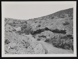
Geologic formations southeast of Boulder City, image 004: photographic print
Date
1930 (year uncertain) to 1933 (year uncertain)
Archival Collection
Description
Geologic formations southeast of Boulder City, Nevada.
Image
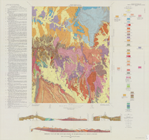
Geologic map of the Topopah Spring NW quadrangle, Nye County, Nevada, 1965
Date
1965
Description
58 x 47 cm., on sheet 84 x 89 cm., folded in envelope 30 x 24 cm. Relief shown by contours and spot heights. "Contour interval 20 feet." "Prepared in cooperation with the U. S. Atomic Energy Commission." "Geology mapped by R. L. Christiansen, P. W. Lipman, and H. R. Cornwall, 1962." Includes text, 3 col. cross sections, and quadrangle location map. Original publisher: Interior, Geological Survey, Series: Geologic quadrangle map GQ, Scale: 1:24 000.
Image
Preliminary Geologic Map of the Moores Station Quadrangle, Nevada - USDOI, Geological Survey, 1970
Level of Description
File
Archival Collection
Yucca Mountain Site Characterization Office Collection
To request this item in person:
Collection Number: MS-00091
Collection Name: Yucca Mountain Site Characterization Office Collection
Box/Folder: Box 74
Collection Name: Yucca Mountain Site Characterization Office Collection
Box/Folder: Box 74
Archival Component
Series X. Geological and topographical maps, approximately 1900 to 1974
Level of Description
Series
Scope and Contents
The geological and topographical maps series (1900-1974) consists of 549 maps and geological sections, illustrating locations primarily in Nevada, California, Arizona, and Utah. Many maps and sections were annotated, illustrated, or color-coded by Longwell.
Archival Collection
Chester R. Longwell Professional Papers
To request this item in person:
Collection Number: MS-00017
Collection Name: Chester R. Longwell Professional Papers
Box/Folder: N/A
Collection Name: Chester R. Longwell Professional Papers
Box/Folder: N/A
Archival Component
Geology research notes, undated
Level of Description
File
Archival Collection
Jeanne Russell Janish Papers
To request this item in person:
Collection Number: MS-00355
Collection Name: Jeanne Russell Janish Papers
Box/Folder: Box 02
Collection Name: Jeanne Russell Janish Papers
Box/Folder: Box 02
Archival Component