Search the Special Collections and Archives Portal
Search Results
Oil Fields of the Great Basin, 1994
Level of Description
File
Archival Collection
David Donovan Collection on Hydrology and Geology
To request this item in person:
Collection Number: MS-00813
Collection Name: David Donovan Collection on Hydrology and Geology
Box/Folder: Box 06
Collection Name: David Donovan Collection on Hydrology and Geology
Box/Folder: Box 06
Archival Component
Sandstones research, 1979-1988
Level of Description
File
Archival Collection
David Donovan Collection on Hydrology and Geology
To request this item in person:
Collection Number: MS-00813
Collection Name: David Donovan Collection on Hydrology and Geology
Box/Folder: Box 11
Collection Name: David Donovan Collection on Hydrology and Geology
Box/Folder: Box 11
Archival Component
Sandstone, Ground-Water Research, 1988
Level of Description
File
Archival Collection
David Donovan Collection on Hydrology and Geology
To request this item in person:
Collection Number: MS-00813
Collection Name: David Donovan Collection on Hydrology and Geology
Box/Folder: Box 12
Collection Name: David Donovan Collection on Hydrology and Geology
Box/Folder: Box 12
Archival Component
Recharge Hydrology Term Paper, 1991
Level of Description
File
Archival Collection
David Donovan Collection on Hydrology and Geology
To request this item in person:
Collection Number: MS-00813
Collection Name: David Donovan Collection on Hydrology and Geology
Box/Folder: Box 12
Collection Name: David Donovan Collection on Hydrology and Geology
Box/Folder: Box 12
Archival Component
Outline of Ground-Water Hydrology, 1965
Level of Description
File
Archival Collection
David Donovan Collection on Hydrology and Geology
To request this item in person:
Collection Number: MS-00813
Collection Name: David Donovan Collection on Hydrology and Geology
Box/Folder: Box 02
Collection Name: David Donovan Collection on Hydrology and Geology
Box/Folder: Box 02
Archival Component
Plants as Indicators of Ground Water, 1927
Level of Description
File
Archival Collection
David Donovan Collection on Hydrology and Geology
To request this item in person:
Collection Number: MS-00813
Collection Name: David Donovan Collection on Hydrology and Geology
Box/Folder: Box 02
Collection Name: David Donovan Collection on Hydrology and Geology
Box/Folder: Box 02
Archival Component
Hydrogeology Journal, 1998 June
Level of Description
File
Archival Collection
David Donovan Collection on Hydrology and Geology
To request this item in person:
Collection Number: MS-00813
Collection Name: David Donovan Collection on Hydrology and Geology
Box/Folder: Box 60
Collection Name: David Donovan Collection on Hydrology and Geology
Box/Folder: Box 60
Archival Component

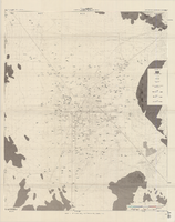
Map of well locations, Las Vegas Valley, Nevada, 1975
Date
1976
Description
'Cartography by Marj Thielke.' 'Prepared in cooperation with the State of Nevada, Department of Conservation and Natural Resources, Division of Water Resources.' Relief shown by contours. Shows township and range lines. Originally published as Plate 1 in Water-level changes associated with ground-water development in Las Vegas Valley, Nevada, 1971-75 : fourth progress report--summary of data / by James R. Harrill, published in 1976 by the Department of Conservation and Natural Resources, Division of Water Resources, as volume 22 of Water resources-information series report. Scale [ca. 1:69,696. 1 in.=approx. 1.1 miles] (W 115°20´--W 115°00´/N 36°20´--N 36°00´).
Image
Pagination
Refine my results
Content Type
Creator or Contributor
Subject
Archival Collection
Digital Project
Resource Type
Year
Material Type
Place
Language
Records Classification


