Search the Special Collections and Archives Portal
Search Results
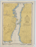
Hydrographic map of Lake Mead, Overton Arm, Southern and Northern Parts
Date
1955-10-17
Description
1st ed., Sept. 1952. Hydrographic chart : color ; 56 x 40 cm. At head of title: United States, Arizona-Nevada. Relief shown by contours, depths shown by soundings. "5458B." "-1952-799." "Catalog page no. 18." On verso: Lake Mead, Overton Arm, southern part. Includes index map. Library's copies have "Compliments of Senator George W. Malone" stamped in red at top on left side. Library's copies have "Corrected through notice to mariners no. 46 Nov. 13 '55" stamped in purple at bottom. Original publisher: U.S. Coast and Geodetic Survey. Scale: 1:48,000
Image
Army Mapping Service Aerial Photographs of Southern and Western Nevada
Identifier
PH-00285
Abstract
The Army Mapping Service Aerial Photographs of Southern and Western Nevada (1952-1956) consist of approximately 2,080 black-and-white high-altitude aerial survey photographs of Southern and Western Nevada. Two projects are represented; 109-G, covering sections of Southern Nevada and 160-BH, covering a section of Western Nevada. Also included are five composite photograph indices created from the detailed survey photographs, four index sheets showing the project locations in Nevada and other projects in the western States, and five photocopied images of composite photographs of several cities in Nevada.
Archival Collection
Survey of the Goldfield Belmont Mining Company, 1900-1925
Date
1900 to 1925
Archival Collection
Description
Survey of the Goldfield Belmont Mining Company, 1900-1925
Image
Pagination
Refine my results
Content Type
Creator or Contributor
Subject
Archival Collection
Digital Project
Resource Type
Year
Material Type
Place
Language
Records Classification

