Search the Special Collections and Archives Portal
Search Results
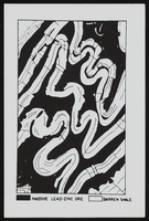
View of folding, ore, and shale: photographic print
Date
1910 (year approximate) to 1930 (year approximate)
Archival Collection
Description
From the Chester R. Longwell Photograph Collection (PH-00311)
Image
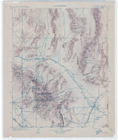
Topographic map of Nevada-California, Las Vegas quadrangle, March 1908
Date
1908-03
Description
'Edition of Mar. 1908.' 'E.M. Douglas, geographer in charge; Topography and triangulation by R.H. Chapman, B.D. Stewart, J.E. Blackburn, and D.F.C. Moor. Surveyed in 1906-1907.' Scale 1:250,000 (W 116°00--W 115°00/N 37°00--N 36°00). Relief shown by contours and spot heights. Title in lower-right corner: Las Vegas. Contour interval 100 feet. Datum is mean sea level. "Topography"--Center of top margin. Text about the Topographic Maps of the United States series and symbols used on map on verso. U.S. Geological Survey
Text

Map of Lincoln County, Nevada and Mohave County, Arizona area, 1892
Date
1892
Description
'Henry Gannett, chief geographer ; A.H. Thompson, geographer in charge ; triangulation by H.M. Wilson ; topography by H.M. Wilson and Powell survey.' 'Edition of Mar. 1892, reprinted 1929.' Handwritten legend on right-side margin of map. Original publisher: Dept. of the Interior, U.S. Geological Survey. Scale 1:250,000
polyconic proj. (W 115°--W 114°/N 37°--N 35°).
polyconic proj. (W 115°--W 114°/N 37°--N 35°).
Image
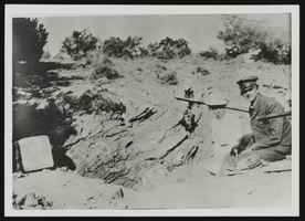
Thorwald and Lou-Vee Bradford Siegfried at a mining claim in Manhattan, Nevada: photographic print
Date
1908 (year approximate) to 1910 (year approximate)
Description
From the Nan Doughty Photograph Collection (PH-00240)
Image
Pagination
Refine my results
Content Type
Creator or Contributor
Subject
Archival Collection
Digital Project
Resource Type
Year
Material Type
Place
Language
Records Classification

