Search Results
Changes in Water Levels and Water Quality in Shallow Ground Water, Pittman-Henderson Area, Clark County, Nevada, Resulting from Diversion of Industrial Cooling Water from Ditch to Pipeline in 1985, 1989
Level of Description
File
Archival Collection
David Donovan Collection on Hydrology and Geology
To request this item in person:
Collection Number: MS-00813
Collection Name: David Donovan Collection on Hydrology and Geology
Box/Folder: Box 54
Collection Name: David Donovan Collection on Hydrology and Geology
Box/Folder: Box 54
Archival Component
Great Basin Paleozoic Carbonate Platform: Facies, Facies Transitions, Depositional Models, Platform Architecture, Sequence Stratigraphy, and Predictive Mineral Host Models, Open-File Report 2004-1078, 2004
Level of Description
File
Archival Collection
David Donovan Collection on Hydrology and Geology
To request this item in person:
Collection Number: MS-00813
Collection Name: David Donovan Collection on Hydrology and Geology
Box/Folder: Box 36
Collection Name: David Donovan Collection on Hydrology and Geology
Box/Folder: Box 36
Archival Component
Environmental Assessment for Kyle Canyon Water District Special Use Permit, Renew and Amend Existing Authorization to Maintain and Improve Potable Water Distribution System in Kyle Canyon, 1995 November
Level of Description
File
Archival Collection
David Donovan Collection on Hydrology and Geology
To request this item in person:
Collection Number: MS-00813
Collection Name: David Donovan Collection on Hydrology and Geology
Box/Folder: Box 40
Collection Name: David Donovan Collection on Hydrology and Geology
Box/Folder: Box 40
Archival Component
Hydrogeologic and Groundwater Modeling Analyses for the Moapa Paiute Energy Center, A Calpine Company Project in Cooperation with the Moapa Band of Paiute Indians, Moapa Indian Reservation, Clark County, Nevada, 2001 February
Level of Description
File
Archival Collection
David Donovan Collection on Hydrology and Geology
To request this item in person:
Collection Number: MS-00813
Collection Name: David Donovan Collection on Hydrology and Geology
Box/Folder: Box 42
Collection Name: David Donovan Collection on Hydrology and Geology
Box/Folder: Box 42
Archival Component
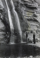
Photograph of a waterfall at Grand Canyon, circa late 1930s
Date
1935 to 1939
Archival Collection
Description
The view of three unidentified gentlemen standing by a waterfall that splashes into the Colorado River located in the rocky Grand Canyon. Located in Arizona, the Grand Canyon was carved by erosion from the Colorado River, which resultantly left the canyon an estimated 277 miles long, a mile deep, and up to 18 miles wide. Today, about two billion years of geological history has been exposed at the canyon.
Image

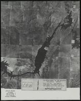
Aerial view of the Bonelli quadrant in Arizona-Nevada: photographic print
Date
1950
Archival Collection
Description
From the Army Mapping Service Aerial Photographs of Southern and Western Nevada (PH-00285). Aerial photographs, composites, and indices. Aerial photographs, Quad. Bonelli 4, U.S. Department of the Interior Geological Survey, Army Map Service. State: Arizona - Nevada. Flight Scale I-47200Project-GS-LJ. Index copied -8-26-50. Flying Comp. -7-26-50
Image
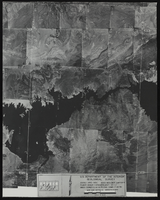
Aerial view of the Boulder Canyon quadrant in Arizona-Nevada: photographic print
Date
1950
Archival Collection
Description
From the Army Mapping Service Aerial Photographs of Southern and Western Nevada (PH-00285). Aerial photographs, composites, and indices. High altitude aerial photographs, Quad. Boulder Canyon 4, State: Arizona - Nevada. U.S. Geological Survey, Army Map Service. Flight Scale I-47200Project-GS-LJ. Index copied -8-26-50. Flying Comp. -7-26-50
Image