Search Results

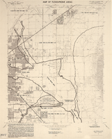
Map of Las Vegas, Nevada, July 1947
Date
Description
Text

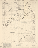
Map of Las Vegas and vicinity, Nevada, circa 1957-1961
Date
Description
Image
Public Response on Repeal of Taft-Hartley 14b. Contains correspondence, notes and memos. [Note: Sample kept of following: For Repeal - 3 x 5 cards = 4,505, Correspondence = 378; Against Repeal - Correspondence = 635, Newspaper = 1,325], 1965 February to 1965 August
Level of Description
Archival Collection
Collection Name: Howard Cannon Papers
Box/Folder: Box 20 (89th Session)
Archival Component
Las Vegas NE quadrangle
Date
Description
Image

Las Vegas NW quadrangle
Date
Description
'Prepared by the U.S. Department of the Interior, Geological Survey, in cooperation with the U.S. Department of Housing and Urban Development, Federal Insurance Administration. 1973.'
Image
Las Vegas SE quadrangle
Date
Description
Image

Las Vegas SW quadrangle
Date
Description
'Prepared by the U.S. Department of the Interior, Geological Survey, in cooperation with the U.S. Department of Housing and Urban Development, Federal Insurance Administration. 1973.'
Image

Map of well locations, Las Vegas Valley, Nevada, 1975
Date
Description
Image

Plat showing original townsite and subdivisions, Las Vegas, Lincoln County, Nevada, May 1905
Date
Description
Land owned by the San Pedro, Los Angeles & Salt Lake Railroad is outlined. Scale: [ca. 1:12,000]. 1 inch = 1,000 feet. Cadastral map. Blueline print. Additional copy available in the J.T. McWilliams manuscript collection
Image

Map of the Las Vegas Strip, 1953
Date
Description
Image