Search Results
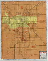
Street map of Las Vegas and vicinity, 1965
Date
1905-05-18
Description
1965 [ed.]. Color; 70 x 55 cm., folded to 24 x 10 cm. Panel title: Las Vegas, North Las Vegas and vicinity street map, home buyers guide. "1/65." Includes names of subdivisions. Index and advertisements for subdivisions on verso. "Compliments of First Western Savings & Loan Association."--Panel. "Drawn by Bob and Beverly Bennett, 1/65." Original publisher: Amusement Guide Publications of America.
Image
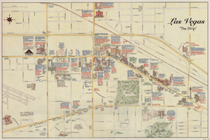
Maps of the Las Vegas Strip, downtown and metropolitan Las Vegas area, the Grand Canyon and southern Nevada, circa 1997
Date
1995 to 1999
Description
'Detail maps for downtown, neighborhoods, out of town, Grand Canyon' -- front panel. Maps on verso: Downtown -- Out of town and short adventures -- Greater Las Vegas -- Grand Canyon, South Rim Village. Major buildings and points of interest on the Las Vegas Strip shown pictorially. Includes text and notes. Originally published by MapEasy, Inc. Scale [ca. 1:10,560. 1 inch to approximately 1/6 mile].
Text
"One Hundred Eighty Cases: A Follow-up by A Rural School Psychologist," California Journal of Educational Research, vol. 9, no. 2 (March 1958): 86-90, 1958
Level of Description
File
Archival Collection
University of Nevada, Las Vegas Faculty Publications
To request this item in person:
Collection Number: UA-00056
Collection Name: University of Nevada, Las Vegas Faculty Publications
Box/Folder: Box 12
Collection Name: University of Nevada, Las Vegas Faculty Publications
Box/Folder: Box 12
Archival Component
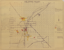
Map of Las Vegas Valley, 1968
Date
1968
Description
'This map compiled by General Drafting Service to show purchases in the Las Vegas area by Howard Hughes and others reported to be affiliated with him.' Shows land owned by Howard Hughes and land owned by Hughes Tool Company. Includes locations of casinos on Las Vegas Strip. Original publisher: General Drafting Service. Scale [ca. 1:48,000]. 1 in. to 4,000 feet. Hand-colored.
Image
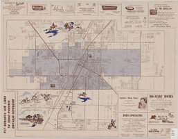
Map of the city of Las Vegas, North Las Vegas, the "Strip", 1957
Date
1957
Description
35 x 50 cm., folded to 22 x 10 cm. Panel title: Inside the greater Las Vegas area. Copyright held by Robert E. Barringer. Map is irregularly shaped. Map of California from San Francisco to Los Angeles to Las Vegas by Beth Bergh, index and advertisements on verso. Includes advertisements for Las Vegas businesses. Stamped on panel of Library's copy: Harrington Insurance Agency. Original publisher: Redwood Publishing Co..
Image
Employees from the Stenographic Office at the Bureau of Reclamation with the following printed description: Hannah Houn, stenographer; Cecile M. Dotson, mails and file clerk; Rose V. Crippa, stenographer, 1931 December 15
Level of Description
File
Archival Collection
Bureau of Reclamation Photographs of the Hoover Dam and Boulder City, Nevada
To request this item in person:
Collection Number: PH-00071
Collection Name: Bureau of Reclamation Photographs of the Hoover Dam and Boulder City, Nevada
Box/Folder: Folder 06 (Restrictions apply)
Collection Name: Bureau of Reclamation Photographs of the Hoover Dam and Boulder City, Nevada
Box/Folder: Folder 06 (Restrictions apply)
Archival Component
Howard Hughes stepping down from his converted B-23 bomber at LaGuardia Field following his transcontinental flight from Culver City to New York, 1946 September 12
Level of Description
File
Archival Collection
Howard Hughes Public Relations Photograph Collection
To request this item in person:
Collection Number: PH-00373
Collection Name: Howard Hughes Public Relations Photograph Collection
Box/Folder: Folder 22
Collection Name: Howard Hughes Public Relations Photograph Collection
Box/Folder: Folder 22
Archival Component