Search Results
Images of Kiel Ranch while a functional ranch, photographs include the following people: Sadie, Willard and George Hampton; Paiute Native Americans; Wally and Ernest Rhoads; Mr. Norton; Charles and daughter Ethel Todd, 1890-1913
Level of Description
File
Archival Collection
Kiel Ranch Preservation Committee Records
To request this item in person:
Collection Number: MS-00650
Collection Name: Kiel Ranch Preservation Committee Records
Box/Folder: Box 07
Collection Name: Kiel Ranch Preservation Committee Records
Box/Folder: Box 07
Archival Component
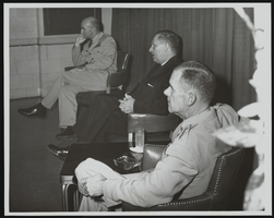
Howard Cannon meets the press following an address to United States Air Force officers graduating from Air University's Command and Staff College Reserve Officer Orientation Course, Maxwell Air Force Base, Alabama: photographic print
Date
1961
Archival Collection
Description
From the Howard Cannon Photograph Collection (PH-00192). Stamped on verso: "Official USAF Photograph Maxwell AFB, Alabama"
Image
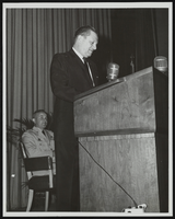
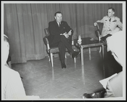

Topographic map of the Las Vegas Valley and surrounding northern and western mountain ranges, 1943
Date
1943
Description
'Edition of Mar. 1908, reprinted 1943.' 'E.M. Douglas, Geographer in charge. Topography and triangulation by R.H. Chapman, B.D. Stewart, J.E. Blackburn and D.F.C. Moor. Surveyed in 1906-1907.' Scale 1:250,000 ; polyconic proj. (W 116°00´--W 115°00´/N 37°00´--N 36°00´). Relief shown by contours and spot heights. 'Contour interval 100 feet.' 'Datum is mean sea level.' Includes township and range lines. Text and illustrations from the Topographic maps of the United States series on verso. Series: The topograhic maps of the United States. Map includes the Desert Range; Sheep Range; Pintwater Range; Las Vegas Range; Spring Mountains; Indian Springs Valley; Spotted Range. United States, Dept. of the Interior, Geological Survey
Text
#72913: Ribbon cutting ceremony of the Makerspace and Multimedia Recording Studios in Lied Library on Thursday, September 6 from 1-2 p.m. The event included a short presentation with ribbon cutting, followed by tours and demonstrations in the new spaces for students, 2019 September 05
Level of Description
Item
Archival Collection
University of Nevada, Las Vegas Creative Services Records (2010s)
To request this item in person:
Collection Number: PH-00388-05
Collection Name: University of Nevada, Las Vegas Creative Services Records (2010s)
Box/Folder: Digital File 01
Collection Name: University of Nevada, Las Vegas Creative Services Records (2010s)
Box/Folder: Digital File 01
Archival Component
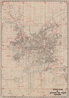
Street map of greater Las Vegas, Nevada, 1984
Date
1984
Description
'The professional street map of greater Las Vegas, Nevada. Detailed guide of Las Vegas, North Las Vegas, Paradise Valley & vicinity' -- front panel. ' Street index on map verso. Original publisher: Front Boy Service Co. Scale [ca. 1:44,352. 1 in. to approx. 0.70 mi.].
Text

Map of city of Las Vegas, Nevada, October 1, 1940
Date
1940-10-01
Description
'Compiled by C.D. Baker, Oct. 1, 1940.' Scale [ca. 1:11,400]. 1 in. to 950 ft. Cadastral map.
Image
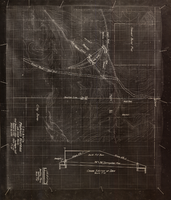
Topographic map showing proposed reservoir for the Las Vegas Rancho, August 4, 1931
Date
1931-08-04
Archival Collection
Description
'Chief Engineers Office, Los Angeles, Calif. August 4, 1931. Scale: 1"=100'. Drawn by L.P.D. 1"=10'.' Accompanies: Letter from R. L. Adamson to F. H. Knickerbocker, August 18, 1931 (Folder 6B: 18-1-9).
Image
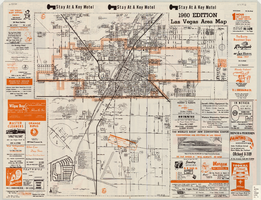
Las Vegas area map, 1960
Date
1960
Description
1960 ed. Scale [ca. 1:47,520. 1 in. equals approx. 0.75 miles.] 1 map : col. ; 41 x 43 cm., folded to 22 x 10 cm. Panel title: Welcome map : greater Las Vegas area and scenic routes to and from there. "1960-61 edition."--Panel. Irregularly-shaped map. Includes list of Las Vegas schools, inset maps of East Las Vegas (Whitney) and Wherry housing area on Nellis Air Force Base and advertisements for Las Vegas businesses. Index, mileages from cities in the United States to Las Vegas and sightseeing information on verso. Library's copy 1 has some art work and some lettering in orange and has "Las Vegas Nevada Chamber of Commerce" stamped in purple on panel. Library's copy 2 has some art work and some lettering in purple and has "Pioneer Title Insurance Co. of Nevada" stamped in black on panel. Nevada State Motel Association?
Text