Search Results
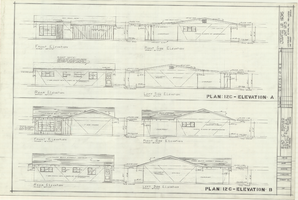
Architectural drawings of residential home in Las Vegas, Nevada, exterior elevations, 1955
Date
1955
Archival Collection
Description
Two different sets of drawings of front, rear, left and right exterior elevations of a ranch-style residential home in the Greater Las Vegas development in Las Vegas, Nevada.
Site Name: Greater Las Vegas
Image
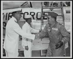
Rear Admiral F. J. Brush greets Howard Cannon immediately following his landing at Naval Station Mayport, Jacksonville, Florida: photographic print
Date
1965-12-17
Archival Collection
Description
From the Howard Cannon Photograph Collection (PH-00192). Stamped on verso: "Official U.S. Navy Photograph - Not for publication unless officially released"
Image
"73: LZM48 of West Side of Las Vegas Boulevard; "We Can Handle it" caboose; "I Follow the Leader," LZM48 at Green Valley Parkway; and trains at Boulder Junction 9360": photographs, 1993 December 07
Level of Description
File
Archival Collection
Ray Tutaj Jr. and Harv Kahn Photographs
To request this item in person:
Collection Number: PH-00456
Collection Name: Ray Tutaj Jr. and Harv Kahn Photographs
Box/Folder: Box 01
Collection Name: Ray Tutaj Jr. and Harv Kahn Photographs
Box/Folder: Box 01
Archival Component
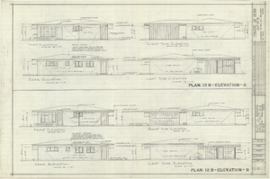
Architectural drawings of residential home in Las Vegas, Nevada, exterior elevations, 1955
Date
1955
Archival Collection
Description
Two different sets of drawings of front, rear, left and right exterior elevations of a ranch-style residential home in the Greater Las Vegas development in Las Vegas, Nevada.
Site Name: Greater Las Vegas
Image
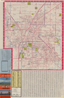
Las Vegas street map and Lake Mead Recreation Area pictorial map, 1979
Date
1979
Description
'Covering Las Vegas, North Las Vegas, Sunrise Manor, Winchester, Paradise and East Las Vegas from Craig Road on the north to Sunset Road on the south and Nellis Boulevard on the east to Jones Boulevard on the west' -- front panel. 'This tourist map has been published by CreaTours, Inc. in co-operation with the North Las Vegas Chamber of Commerce." 3rd ed. Scale [ca. 1:31,680. 1 in. to approx. 0.5 miles]. Includes indexes. Pictorial map of Lake Mead National Recreation Area on verso, by Cliff Segerblom. 'Lithographed by Creel Printing Company, Las Vegas, Nev.' Second edition, copyright 1977. 'Map not to scale due to artistic license.' Advertisements on map verso.
Text

Plat of H.F.M & M addition to city of Las Vegas, Clark County, Nevada, comprising the west 1/2 of N.W. 1/4 Sec. 27, Twp. 20 S., R. 61 E., M.D.B & M, March 8, 1924
Date
1924-03-08
Description
Blue-line print ; 74 x 36 cm on sheet 79 x 61 cm. Survey was competed on March 8, 1924. Signed by the owners of the piece of property for the addition Roy W. Martin, Forest R. Mildren, William E. Ferron, and A. W. Ham, signed by the surveyor J.T. McWilliams, and notarized on March 31, 1924. Approved by the Board of City Commissioners and signed by the major W. C. German and by Florence S. Doherty, city clerk, on April 1, 1924. Recorded in Book 1 of plats, page 47. Includes township and range grid.
Image
Status of Virgin River Chub and Other Fishes of the Muddy River Following 1995 Invasion of Blue Tilapia in Warm Springs Area, 2004
Level of Description
File
Archival Collection
Jeff Van Ee Papers
To request this item in person:
Collection Number: MS-00470
Collection Name: Jeff Van Ee Papers
Box/Folder: Box 05
Collection Name: Jeff Van Ee Papers
Box/Folder: Box 05
Archival Component
XF-11 plane's second flight immediately following take-off at the Hughes Airport in Culver City, California, 1947 April 04
Level of Description
File
Archival Collection
Howard Hughes Professional and Aeronautical Photographs
To request this item in person:
Collection Number: PH-00321
Collection Name: Howard Hughes Professional and Aeronautical Photographs
Box/Folder: Folder 07
Collection Name: Howard Hughes Professional and Aeronautical Photographs
Box/Folder: Folder 07
Archival Component
Old Mormon and 49er road which followed the Spanish Trail. Looking west from Immigrant (sic) Pass, October 1967
Level of Description
File
Archival Collection
Sherwin "Scoop" Garside Papers
To request this item in person:
Collection Number: MS-00342
Collection Name: Sherwin "Scoop" Garside Papers
Box/Folder: Box 01
Collection Name: Sherwin "Scoop" Garside Papers
Box/Folder: Box 01
Archival Component

Map of Boulder Dam area and Las Vegas, Nevada, October 7, 1930
Date
1930-10-07
Description
'F.V. Owen, publisher ... Los Angeles, California. Topography by C.H. Fenner, C.E. Decorations by L.J. Bergère. Gov't. data, H.A. Shamberger, C.E. Copyright, 1930, by F.V. Owen.' At bottom right of map: 'Dated Oct. 7th, 1930.' Relief shown by contours and spot heights. Contour lines are 100 feet. Incudes six hand-colored illustrations showing local points of interest. Includes information on Hoover Dam, and chart of mileages from Las Vegas. Scale [ca. 1:63,360]. 1 inch to 1 mile
Text