Search Results
Plat of original townsite of Las Vegas, Clark County, Nevada, November 25, 1927
Date
Description
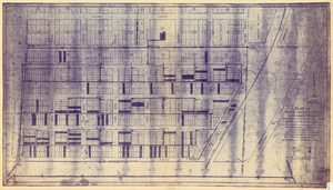
Subtitle: 'On N 1/2 of SW 1/4 section 27, T 20 S, R 61 E, M.D. Mer. showing cast iron water mains. Including location and distances of valves, fire hydrants, house connections, etc. Constructed by Las Vegas Land &Water Company. Construction completed Nov. 25-1927. Cast iron pipe system throughout made at Provo, Utah by Pacific States Cast Iron Pipe Company. R.N. Clark, Construction Engineer. Map and survey made by J.T. McWilliams, C.E., Las Vegas, Nev.' Map shows ownership of some parcels of land. Scale [ca. 1:960]. 1 inch to 80 feet. Blueline print. Plat map.
Image
Ness, Kristian. Follow the Yellow Brick Road, ChristopherStreet, 1995 April
Level of Description
Archival Collection
Collection Name: UNLV Libraries Collection of Articles on Gaming and Las Vegas, Nevada Topics
Box/Folder: Box 19
Archival Component

Original plat, townsite of Las Vegas, Lincoln Co., Nevada, January 13, 1905
Date
Description
Subtitle: 'Embracing the N. 1/2 of S.W. 1/4 Sec. 27 Township 20S. R.61E. Mt. Diablo Meridian.' 'Book 1, page 17A" handwritten in lower right corner. Signed by Henry Lee, County Recorder, Lincoln County Nevada. 'Filed at request of J.T. Williams, January 13th A.D. 1905.' Backwards handwriting on right side. Map has a Lincoln County seal on the bottom near the center. In the dedication J.T. McWilliams states that he has surveyed and platted the townsite of Las Vegas subject to the right of way of the San Pedro, Los Angeles and Salt Lake Railroad Company. He signed the dedication on Jan. 13, 1905, and it was signed by witnesses Scale [ca. 1:2,520? 1 inch to approx. 210 feet?]. Copy of a blueline print.
Image
Follow The Fleet #96: parts, approximately 1950 to 1967
Level of Description
Archival Collection
Collection Name: Russ Morgan Music Manuscripts
Box/Folder: Box 076
Archival Component
Follow The Fleet #96: score, approximately 1950 to 1967
Level of Description
Archival Collection
Collection Name: Russ Morgan Music Manuscripts
Box/Folder: Oversized Box 237
Archival Component
Observed Damage at Groom Mine Following Shot of Plumbbob, July 9, 1964
Level of Description
Archival Collection
Collection Name: Alice P. Broudy Papers on Broudy v. United States
Box/Folder: Box 24
Archival Component
"I Follow the Forest Flame Bird" manuscript draft, approximately 1980 to 2020
Level of Description
Archival Collection
Collection Name: Stephen G. Brown Literary Papers
Box/Folder: Box 12, Box 15
Archival Component

Map of Las Vegas and vicinity, Nevada, circa 1957-1961
Date
Description
Image

Map of Las Vegas, Nevada, July 1947
Date
Description
Text

Plat showing original townsite and subdivisions, Las Vegas, Lincoln County, Nevada, May 1905
Date
Description
Land owned by the San Pedro, Los Angeles & Salt Lake Railroad is outlined. Scale: [ca. 1:12,000]. 1 inch = 1,000 feet. Cadastral map. Blueline print. Additional copy available in the J.T. McWilliams manuscript collection
Image