Search Results

Street map of the city of Las Vegas & vicinity, showing streets, main roads and recreation areas, 1954
Date
Description
Image

Map of Las Vegas and vicinity, Clark County, Nevada, December 1954
Date
Description
Image

Topographic map of the Las Vegas Valley area, 1959
Date
Description
Image

Topographic map of groundwater in the southeast quadrangle of Las Vegas, Nevada, 1980
Date
Description
Text

Map of Las Vegas, Nevada and surrounding Bureau of Land Management areas to the west and north, 1994
Date
Description
Text
Photographs of Ole's Store 671 employees, including the following individuals: Louis Riggs, Chris Hunt, Bonnie Davis, Bernice Johnson, Miguel Torres, Marie Imus, Dana Schafer, Bill Lowe, Richard Diedrick, Colleen Schneider, Judy Kazel, and Rex Paulson, 1987-1988
Level of Description
Archival Collection
Collection Name: Von Tobel Family Papers
Box/Folder: Box 04
Archival Component
Paul Cummings dialog rehearsals [1968] (side A); Lavern Cummings [1966] sings "Almost in Your Arms;" "Wrap Your Troubles in Dreams;" "That Rainy Day is Here;" and "Love Me With All Your Heart;" followed by unintelligible recording of televised programs (side B), approximately 1966 to 1968
Level of Description
Archival Collection
Collection Name: Paul Lavern Cummings Papers
Box/Folder: Box 09
Archival Component
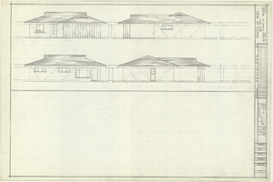
Architectural drawings of residential home in Las Vegas, Nevada, exterior elevations, 1955
Date
Archival Collection
Description
Drawings of exterior elevations of a ranch-style residential home in the Greater Las Vegas development in Las Vegas, Nevada. Handwritten underneath drawings at right: "Plan 14C - Elev. C."
Site Name: Greater Las Vegas
Image

Map of Las Vegas Rancho, Lincoln County, Nevada, September 15, 1904
Date
Description
Image
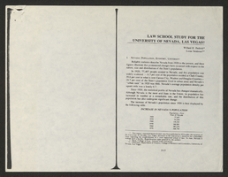
Law School Study for the University of Nevada, Las Vegas from Southwestern-Nevada Law Review
Date
Archival Collection
Description
A loose paper version of "Law School Study for the University of Nevada, Las Vegas" by Willard H. Pedrick and Lorne Seidman, photocopied from the Southwestern-Nevada Law Review, Volume 10, 1978. From the University of Nevada, Las Vegas William S. Boyd School of Law Records (UA-00048).
Text