Search Results

Redevelopment plan map for downtown Las Vegas, Nevada, November 18, 1987
Date
1987-11-18
Description
Scale [ca. 1:12,000. 1 inch equals approx. 1,000 feet]. 1 map ; on sheet 61 x 46 cm. "Nov. 18, 1987." "All land use designations on this map are to be interpreted in conformance with the community profiles component of the Las Vegas General Plan." City of Las Vegas?.
Image
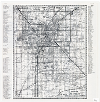
Map of greater Las Vegas area, 1964-1965
Date
1964 to 1965
Description
Scale [ca. 1:51,322] ; 1 map ; 55 x 43 cm ; Panel title: Front Boy's official 1964-1965 edition street map : detailed guide of North Las Vegas, Las Vegas, Paradise Valley and vicinity ; Originally folded to: 29 x 12 cm ; Relief shown by spot heights ; Includes notes and quotations ; Includes indexes; Alt Title: Front Boy's official 1964-1965 edition street map : detailed guide of North Las Vegas, Las Vegas, Paradise Valley and vicinity ; Alt Title: Official 1964-1965 edition street map Front Boy Service Co..
Text

Map of the Las Vegas Strip, 1953
Date
1953
Description
Scale [ca. 1:9,600. 1 in. to approx. 800 ft.] ; 1 map : col. ; 57 x 29 cm ; Cadastral map ; Campbell Realty Company.
Image
#71160: The second Presidential Debate Watch Party held inside Greenspun Auditorium on October 9, 2016. Following the broadcast of the debate from St. Louis panelists Jacob Thompson, Michael Eisenstadt, Michael Green and David Fott took questions from the audience, 2016 October 09
Level of Description
Item
Archival Collection
University of Nevada, Las Vegas Creative Services Records (2010s)
To request this item in person:
Collection Number: PH-00388-05
Collection Name: University of Nevada, Las Vegas Creative Services Records (2010s)
Box/Folder: Digital File 01
Collection Name: University of Nevada, Las Vegas Creative Services Records (2010s)
Box/Folder: Digital File 01
Archival Component

Map of Las Vegas Valley showing artesian wells, circa 1920
Date
1918 to 1922
Description
Scale not given ; 1 map ; 66 x 55 cm ; Blueline print ; Cadastral map ; Includes township and range grid ; Includes quotations McWilliams?
Image
Photographs of Ole's Store 671 employees, including the following individuals: Louis Riggs, Chris Hunt, Bonnie Davis, Bernice Johnson, Miguel Torres, Marie Imus, Dana Schafer, Bill Lowe, Richard Diedrick, Colleen Schneider, Judy Kazel, and Rex Paulson, 1987-1988
Level of Description
Item
Archival Collection
Von Tobel Family Papers
To request this item in person:
Collection Number: MS-00589
Collection Name: Von Tobel Family Papers
Box/Folder: Box 04
Collection Name: Von Tobel Family Papers
Box/Folder: Box 04
Archival Component
Paul Cummings dialog rehearsals [1968] (side A); Lavern Cummings [1966] sings "Almost in Your Arms;" "Wrap Your Troubles in Dreams;" "That Rainy Day is Here;" and "Love Me With All Your Heart;" followed by unintelligible recording of televised programs (side B), approximately 1966 to 1968
Level of Description
Item
Archival Collection
Paul Lavern Cummings Papers
To request this item in person:
Collection Number: MS-00971
Collection Name: Paul Lavern Cummings Papers
Box/Folder: Box 09
Collection Name: Paul Lavern Cummings Papers
Box/Folder: Box 09
Archival Component

Map of the Las Vegas Strip, May 1950
Date
1950-05
Description
Scale [ca. 1:10,200. 1 in. to approx. 850 ft.] ; 1 map : col. ; 54 x 28 cm ; Cadastral map ; "May 1950." Campbell Realty.
Image
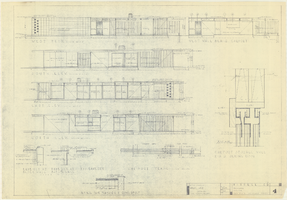
Architectural drawings of a residential home in Las Vegas, Nevada, November 2, 1962
Date
1963-11-02
Description
Exterior elevations and details for a residential home on Fifth Place in Las Vegas, Nevada. Sheet no. 4. "Drw. D.H."
Architecture Period: Mid-Century ModernistImage
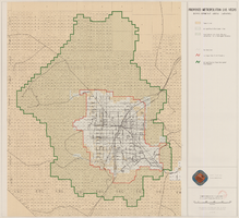
Map showing proposed metropolitan Las Vegas development area, June 24, 1997
Date
1997-06-24
Description
'Data sources: Advanced Planning Division, Clark County, Nevada.' 'Comprehensive Planning, Advanced Planning Division.' 'June 24, 1997.' Shows federal land, metropolitan Las Vegas development area, Las Vegas urban growth boundary and section lines. Scale [ca. 1:154,056. 1 inch to approx. 12,838 feet].
Image