Search Results
Follow The Fleet #96: parts, approximately 1950 to 1967
Level of Description
Archival Collection
Collection Name: Russ Morgan Music Manuscripts
Box/Folder: Box 076
Archival Component
Follow The Fleet #96: score, approximately 1950 to 1967
Level of Description
Archival Collection
Collection Name: Russ Morgan Music Manuscripts
Box/Folder: Oversized Box 237
Archival Component

Plat showing original townsite and subdivisions, Las Vegas, Lincoln County, Nevada, May 1905
Date
Description
Land owned by the San Pedro, Los Angeles & Salt Lake Railroad is outlined. Scale: [ca. 1:12,000]. 1 inch = 1,000 feet. Cadastral map. Blueline print. Additional copy available in the J.T. McWilliams manuscript collection
Image
"I Follow the Forest Flame Bird" manuscript draft, approximately 1980 to 2020
Level of Description
Archival Collection
Collection Name: Stephen G. Brown Literary Papers
Box/Folder: Box 12, Box 15
Archival Component
Observed Damage at Groom Mine Following Shot of Plumbbob, July 9, 1964
Level of Description
Archival Collection
Collection Name: Alice P. Broudy Papers on Broudy v. United States
Box/Folder: Box 24
Archival Component

Map of the Las Vegas Strip, 1953
Date
Description
Image

Redevelopment plan map for downtown Las Vegas, Nevada, November 18, 1987
Date
Description
Image
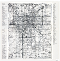
Map of greater Las Vegas area, 1964-1965
Date
Description
Text
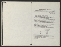
Law School Study for the University of Nevada, Las Vegas from Southwestern-Nevada Law Review
Date
Archival Collection
Description
A loose paper version of "Law School Study for the University of Nevada, Las Vegas" by Willard H. Pedrick and Lorne Seidman, photocopied from the Southwestern-Nevada Law Review, Volume 10, 1978. From the University of Nevada, Las Vegas William S. Boyd School of Law Records (UA-00048).
Text

Map of Las Vegas Valley showing artesian wells, circa 1920
Date
Description
Image