Search Results

Redevelopment plan map for downtown Las Vegas, Nevada, November 18, 1987
Date
Description
Image
#69217: Students from around the U.S. participating in the National Junior Classical League convention run a foot race around campus as a nod to Pheidippides' run from Marathon to Athens following the Battle of Marathon in 490 B.C. The annual gathering of Classics students was hosted by UNLV, July 24, 2013, 2013 July 24
Level of Description
Archival Collection
Collection Name: University of Nevada, Las Vegas Creative Services Records (2010s)
Box/Folder: Digital File 00
Archival Component

Plat showing original townsite and subdivisions, Las Vegas, Lincoln County, Nevada, May 1905
Date
Description
Land owned by the San Pedro, Los Angeles & Salt Lake Railroad is outlined. Scale: [ca. 1:12,000]. 1 inch = 1,000 feet. Cadastral map. Blueline print. Additional copy available in the J.T. McWilliams manuscript collection
Image
"49: Telephone pole on Boulder Ranch Spur; 3354 at MP325, LZM48 3746 between Las Vegas Boulevard and sunset crossing with Landmark Hilton Sign and Stupak Tower with McCarren Airport; Caboose of LZM48 "I Follow the Leader" with Luxor, MGM , Landmark; 9050 "All you need is love," LZM48 West at Desk Hendon; Landmark and Hilton Sign Stupak Tower": photographs, 1994 March
Level of Description
Archival Collection
Collection Name: Ray Tutaj Jr. and Harv Kahn Photographs
Box/Folder: Box 01
Archival Component

Map of Las Vegas Valley showing artesian wells, circa 1920
Date
Description
Image
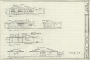
Architectural drawings of residential home in Las Vegas, Nevada, exterior elevations, May 23, 1958
Date
Archival Collection
Description
Front, right, rear and left exterior elevations of a ranch-style residential home and detached garage in the Las Verdes Heights development in Las Vegas, Nevada. "Drawn by J.C.M. & P.J.C. Checked by E.C.B." "Sheet no. 8 of 25."
Site Name: Las Verdes Heights
Image
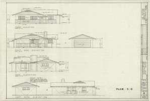
Architectural drawings of residential home in Las Vegas, Nevada, exterior elevations, May 23, 1958
Date
Archival Collection
Description
Front, right, rear and left exterior elevations of a ranch-style residential home with detached garage in the Las Verdes Heights development in Las Vegas, Nevada. "Drawn by P.J.C. & J.C.M. Checked by E.C.B." "Sheet no. 9 of 25."
Site Name: Las Verdes Heights
Image

Map of the Las Vegas Strip, May 1950
Date
Description
Image
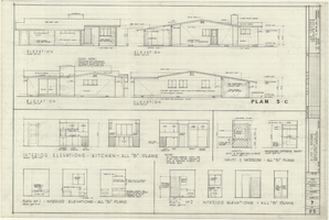
Architectural drawings of residential home in Las Vegas, Nevada, exterior elevations, May 23, 1958
Date
Archival Collection
Description
Exterior and interior elevations of a ranch-style residential home in the Las Verdes Heights development in Las Vegas, Nevada. Interior elevations for kitchen, bathrooms and vanity and wardrobe shown. "Drawn by J.C.M. Checked by E.C.B." "Sheet no. 7 of 25."
Site Name: Las Verdes Heights
Image
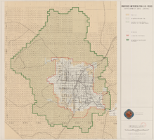
Map showing proposed metropolitan Las Vegas development area, June 24, 1997
Date
Description
Image