Search Results
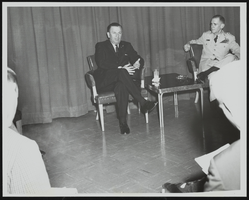
Howard Cannon meets the press following an address to United States Air Force officers graduating from Air University's Command and Staff College Reserve Officer Orientation Course, Maxwell Air Force Base, Alabama: photographic print
Date
Archival Collection
Description
Image
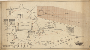
Map showing proposed improvements of Las Vegas Springs, Las Vegas, Nevada, January 26, 1918
Date
Archival Collection
Description
'Exhibit A'. 'Approved Jan. 26, 1918.' Includes discharge figures and plans for improvements to springs for the municipal water system including diagrams of spillway openings, etc. Scale [ca. 1:1200] 1 in.=100 feet -- Scale [ca. 1:120] 1 in.=10 feet -- Scale [ca. 1:240] 1 in.=20 feet -- Scale [ca. 1:24] 1 in.=2 feet -- Scale [ca. 1:2400] 1 in.=200 feet. Vertical scale [ca. 1:48] 1 in.=4 feet -- Scale [ca. 1:12] 1 in.=1 foot.
Image
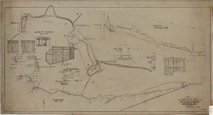
Map showing proposed improvement of Las Vegas Springs, Las Vegas, Nevada, September 21, 1916
Date
Description
'Exhibit A'. 'Approved Sept. 21, 1916.' 'W.E.J.'"--Lower left corner. 'L-44-50 to 61. T-75 - 17 & 46'--Upper left corner. Includes discharge figures and plans for improvements to springs Scale [ca. 1:240]. 1 in. to 20 feet. -- Scale [ca. 1:2,400]. 1 in. to 200 ft. Vertical scale [ca. 1:48]. 1 in. to 4 feet. -- Scale [ca. 1:4,800]. 1 in. to 100 feet. Library's copy has "Proposed layout" written on it in pencil near lower center and other markings in red. Contents: Detail at springs -- Profile -- Alignment.
Image
#72913: Ribbon cutting ceremony of the Makerspace and Multimedia Recording Studios in Lied Library on Thursday, September 6 from 1-2 p.m. The event included a short presentation with ribbon cutting, followed by tours and demonstrations in the new spaces for students, 2019 September 05
Level of Description
Archival Collection
Collection Name: University of Nevada, Las Vegas Creative Services Records (2010s)
Box/Folder: Digital File 01
Archival Component
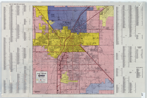
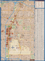
A general map of Las Vegas, 1969
Date
Description
Image
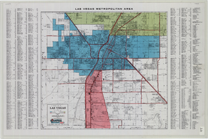
Maps of Las Vegas metropolitan area, Grand Canyon National Park and national parks near Las Vegas, Nevada, 2008
Date
Description
Text

City of Las Vegas map, 1952
Date
Description
Text
General map of Las Vegas, Nevada, June 1962
Date
Description
Text

Topographic map of Nevada-California, Las Vegas quadrangle, March 1908
Date
Description
Text

Map of metropolitan Las Vegas, Nevada area, circa 1957
Date
Description
Text