Search Results

Topographic map of the southeast quadrangle of the metropolitan Las Vegas, Nevada area, 1984
Date
Description
Image

Map of Las Vegas and vicinity, Clark County, Nevada, December 1954
Date
Description
Image

Topographic map of the Las Vegas Valley area, 1959
Date
Description
Image

Topographic map of groundwater in the southeast quadrangle of Las Vegas, Nevada, 1980
Date
Description
Text

Map of Las Vegas, Nevada and surrounding Bureau of Land Management areas to the west and north, 1994
Date
Description
Text
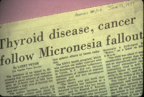
Newspaper headline: “Thyroid Disease, Cancer Follows Micronesia Fallout.”: photographic slide
Date
Archival Collection
Description
From the Sister Klaryta Antoszewska Photograph Collection (PH-00352). Written on the newspaper: "Honolulu Adv./S.B June 12, 1977".
Image
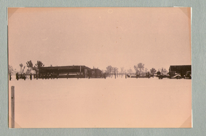
Ranch buildings following snowstorm at Walking Box Ranch, Nevada: photographic print
Date
Archival Collection
Description
Bell Family Scrapbook scanning, Set 4, proofed 11.04.2010 Snow at the Walking Box Ranch. Various ranch buildings in the background
Image
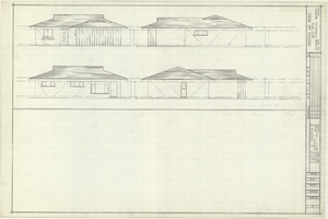
Architectural drawings of residential home in Las Vegas, Nevada, exterior elevations, 1955
Date
Archival Collection
Description
Drawings of exterior elevations of a ranch-style residential home in the Greater Las Vegas development in Las Vegas, Nevada. Handwritten underneath drawings at right: "Plan 14C - Elev. C."
Site Name: Greater Las Vegas
Image
Donations made in name of Louis Wiener, Jr. following his death, 1996
Level of Description
Archival Collection
Collection Name: Valerie Wiener Papers
Box/Folder: Box 06
Archival Component
2017 Gaming Gender Equality Index corporation follow-up interviews, 2017
Level of Description
Archival Collection
Collection Name: Women of Diversity Productions, Inc. Records
Box/Folder: Box 09
Archival Component