
Search the Special Collections and Archives Portal

Search Results

Display    Results Per Page
Displaying results 141 - 150 of 628464

Follow The Fleet #96: score, approximately 1950 to 1967

Level of Description

File

Archival Collection

Russ Morgan Music Manuscripts
To request this item in person:
Collection Number: MS-00944
Collection Name: Russ Morgan Music Manuscripts
Box/Folder: Oversized Box 237

Archival Component

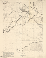
Las Vegas SE quadrangle

Date

1973

Description

'Prepared by the U.S. Department of the Interior, Geological Survey, in cooperation with the U.S. Department of Housing and Urban Development, Federal Insurance Administration. 1973.'

Image

Las Vegas SW quadrangle

Date

1973

Description

'Prepared by the U.S. Department of the Interior, Geological Survey, in cooperation with the U.S. Department of Housing and Urban Development, Federal Insurance Administration. 1973.'

Image

Observed Damage at Groom Mine Following Shot of Plumbbob, July 9, 1964

Level of Description

Item

Archival Collection

Alice P. Broudy Papers on Broudy v. United States
To request this item in person:
Collection Number: MS-00097
Collection Name: Alice P. Broudy Papers on Broudy v. United States
Box/Folder: Box 24

Archival Component

"I Follow the Forest Flame Bird" manuscript draft, approximately 1980 to 2020

Level of Description

File

Archival Collection

Stephen G. Brown Literary Papers
To request this item in person:
Collection Number: MS-01090
Collection Name: Stephen G. Brown Literary Papers
Box/Folder: Box 12, Box 15

Archival Component

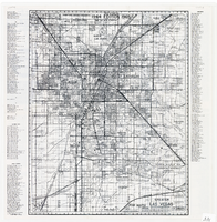
Map of greater Las Vegas area, 1964-1965

Date

1964 to 1965

Description

Scale [ca. 1:51,322] ; 1 map ; 55 x 43 cm ; Panel title: Front Boy's official 1964-1965 edition street map : detailed guide of North Las Vegas, Las Vegas, Paradise Valley and vicinity ; Originally folded to: 29 x 12 cm ; Relief shown by spot heights ; Includes notes and quotations ; Includes indexes; Alt Title: Front Boy's official 1964-1965 edition street map : detailed guide of North Las Vegas, Las Vegas, Paradise Valley and vicinity ; Alt Title: Official 1964-1965 edition street map Front Boy Service Co..

Text

Map of the Las Vegas Strip, 1953

Date

1953

Description

Scale [ca. 1:9,600. 1 in. to approx. 800 ft.] ; 1 map : col. ; 57 x 29 cm ; Cadastral map ; Campbell Realty Company.

Image

Redevelopment plan map for downtown Las Vegas, Nevada, November 18, 1987

Date

1987-11-18

Description

Scale [ca. 1:12,000. 1 inch equals approx. 1,000 feet]. 1 map ; on sheet 61 x 46 cm. "Nov. 18, 1987." "All land use designations on this map are to be interpreted in conformance with the community profiles component of the Las Vegas General Plan." City of Las Vegas?.

Image

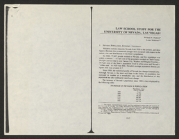
Law School Study for the University of Nevada, Las Vegas from Southwestern-Nevada Law Review

Date

1978

Description

A loose paper version of "Law School Study for the University of Nevada, Las Vegas" by Willard H. Pedrick and Lorne Seidman, photocopied from the Southwestern-Nevada Law Review, Volume 10, 1978. From the University of Nevada, Las Vegas William S. Boyd School of Law Records (UA-00048).

Text

Map of Las Vegas Valley showing artesian wells, circa 1920

Date

1918 to 1922

Description

Scale not given ; 1 map ; 66 x 55 cm ; Blueline print ; Cadastral map ; Includes township and range grid ; Includes quotations McWilliams?

Image