Search Results
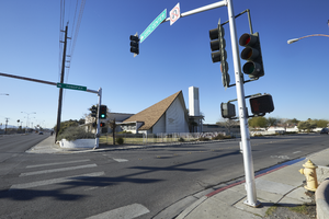
The Church of Jesus Christ of Latter-day Saints on East Tonopah Avenue and Civic Center Drive, looking south-southwest in North Las Vegas, Nevada: digital photograph
Date
Archival Collection
Description
From the UNLV University Libraries Photographs of the Development of the Las Vegas Valley, Nevada (PH-00394). Part of the collection documents the entire 19 mile length of the north/south Eastern Avenue / Civic Center Drive alignment. This photograph was captured in the section of Civic Center Drive and Eastern Avenue between Lake Mead Boulevard and Washington Avenue.
Image
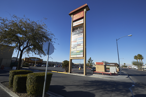
Shopping center marquee on Lake Mead Boulevard near Civic Center Drive, looking southwest in North Las Vegas, Nevada: digital photograph
Date
Archival Collection
Description
From the UNLV University Libraries Photographs of the Development of the Las Vegas Valley, Nevada (PH-00394). Part of the collection documents the entire 19 mile length of the north/south Eastern Avenue / Civic Center Drive alignment. This photograph was captured in the section of Civic Center Drive and Eastern Avenue between Lake Mead Boulevard and Washington Avenue.
Image
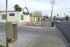
Residential housing converted to business property on Eastern Avenue near East Wilson Avenue, looking north-northwest in Las Vegas, Nevada: digital photograph
Date
Archival Collection
Description
From the UNLV University Libraries Photographs of the Development of the Las Vegas Valley, Nevada (PH-00394). Part of the collection documents the entire 19 mile length of the north/south Eastern Avenue / Civic Center Drive alignment. This photograph was captured in the section of Eastern Avenue between Washington and Stewart Avenues.
Image
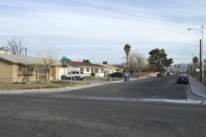
Residential housing at North 24th Street and East Kirk Avenue near Eastern Avenue, looking north-northwest in Las Vegas, Nevada: digital photograph
Date
Archival Collection
Description
From the UNLV University Libraries Photographs of the Development of the Las Vegas Valley, Nevada (PH-00394). Part of the collection documents the entire 19 mile length of the north/south Eastern Avenue / Civic Center Drive alignment. This photograph was captured in the section of Eastern Avenue between Washington and Stewart Avenues.
Image
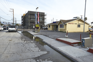
An office building under construction at the intersection of Washington and Eastern Avenues with a converted residential house now used as a business, looking north in Las Vegas, Nevada: digital photograph
Date
Archival Collection
Description
From the UNLV University Libraries Photographs of the Development of the Las Vegas Valley, Nevada (PH-00394). Part of the collection documents the entire 19 mile length of the north/south Eastern Avenue / Civic Center Drive alignment. This photograph was captured in the section of Eastern Avenue between Washington and Stewart Avenues.
Image
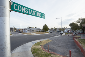
A street sign for East Constantine Avenue frames a mixed use residential neighborhood with some homes that have been converted for use as businesses, looking northeast in Las Vegas, Nevada: digital photograph
Date
Archival Collection
Description
From the UNLV University Libraries Photographs of the Development of the Las Vegas Valley, Nevada (PH-00394). Part of the collection documents the entire 19 mile length of the north/south Eastern Avenue / Civic Center Drive alignment. This photograph was captured in the section of Eastern Avenue between Washington and Stewart Avenues.
Image

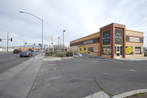
The Terrible Herbst Chevron gas station on Eastern Avenue near the US 95 overpass, looking south-southeast in Las Vegas, Nevada: digital photograph
Date
Archival Collection
Description
From the UNLV University Libraries Photographs of the Development of the Las Vegas Valley, Nevada (PH-00394). Part of the collection documents the entire 19 mile length of the north/south Eastern Avenue / Civic Center Drive alignment. This photograph was captured in the section of Eastern Avenue between Washington and Stewart Avenues.
Image
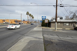
Exterior view of Flauteria Mexican Food on Eastern Avenue near the US 95 overpass, looking north-northeast in Las Vegas, Nevada: digital photograph
Date
Archival Collection
Description
From the UNLV University Libraries Photographs of the Development of the Las Vegas Valley, Nevada (PH-00394). Part of the collection documents the entire 19 mile length of the north/south Eastern Avenue / Civic Center Drive alignment. This photograph was captured in the section of Eastern Avenue between Washington and Stewart Avenues.
Image
Businesses and apartments mix use area off Eastern Avenue near US 95, looking north-northwest in Las Vegas, Nevada: digital photograph
Date
Archival Collection
Description
From the UNLV University Libraries Photographs of the Development of the Las Vegas Valley, Nevada (PH-00394). Part of the collection documents the entire 19 mile length of the north/south Eastern Avenue / Civic Center Drive alignment. This photograph was captured in the section of Eastern Avenue between Washington and Stewart Avenues.
Image
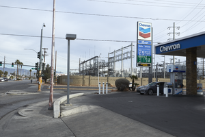
A Chevron gas station sits on the southeast corner of Eastern and Bonanza Avenues as an NV Energy substation fills the opposite side of Bonanza, looking north in Las Vegas, Nevada: digital photograph
Date
Archival Collection
Description
From the UNLV University Libraries Photographs of the Development of the Las Vegas Valley, Nevada (PH-00394). Part of the collection documents the entire 19 mile length of the north/south Eastern Avenue / Civic Center Drive alignment. This photograph was captured in the section of Eastern Avenue between Washington and Stewart Avenues.
Image