Search Results
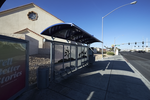
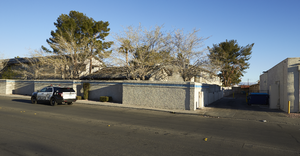
A bus shelter sits our front of St. Viator Catholic Church on Flamingo Road near Eastern Avenue, looking southwest in Las Vegas, Nevada: digital photograph
Date
Archival Collection
Description
From the UNLV University Libraries Photographs of the Development of the Las Vegas Valley, Nevada (PH-00394). Part of the collection documents the entire 19 mile length of the north/south Eastern Avenue / Civic Center Drive alignment. This photograph was captured in the section of Eastern Avenue between Flamingo Road and Tropicana Avenue.
Image
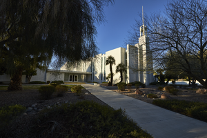
Exterior view of a Church of Jesus Christ of Latter Day Saints on Tropicana Avenue near Eastern Avenue, looking south-southwest in Las Vegas, Nevada: digital photograph
Date
Archival Collection
Description
From the UNLV University Libraries Photographs of the Development of the Las Vegas Valley, Nevada (PH-00394). Part of the collection documents the entire 19 mile length of the north/south Eastern Avenue / Civic Center Drive alignment. This photograph was captured in the section of Eastern Avenue between Tropicana Avenue and Russell Road.
Image
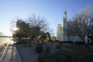
Exterior view of Church of Jesus Christ of Latter Day Saints on Tropicana Avenue near Eastern Avenue, looking southeast in Las Vegas, Nevada: digital photograph
Date
Archival Collection
Description
From the UNLV University Libraries Photographs of the Development of the Las Vegas Valley, Nevada (PH-00394). Part of the collection documents the entire 19 mile length of the north/south Eastern Avenue / Civic Center Drive alignment. This photograph was captured in the section of Eastern Avenue between Tropicana Avenue and Russell Road.
Image
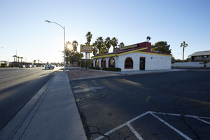
Exterior view of a payday loan business on Tropicana Avenue near Eastern Avenue, looking east-southeast in Las Vegas, Nevada: digital photograph
Date
Archival Collection
Description
From the UNLV University Libraries Photographs of the Development of the Las Vegas Valley, Nevada (PH-00394). Part of the collection documents the entire 19 mile length of the north/south Eastern Avenue / Civic Center Drive alignment. This photograph was captured in the section of Eastern Avenue between Tropicana Avenue and Russell Road.
Image
A multifamily residential area sits behind a commercial center on Reno and Eastern Avenues near Tropicana Avenue, looking north-west in Las Vegas, Nevada: digital photograph
Date
Archival Collection
Description
From the UNLV University Libraries Photographs of the Development of the Las Vegas Valley, Nevada (PH-00394). Part of the collection documents the entire 19 mile length of the north/south Eastern Avenue / Civic Center Drive alignment. This photograph was captured in the section of Eastern Avenue between Tropicana Avenue and Russell Road.
Image
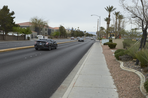
Cars travel down Serene Avenue, which is flanked by multi-family and commercial development, near Eastern Avenue, looking west-southwest in Las Vegas, Nevada: digital photograph
Date
Archival Collection
Description
From the UNLV University Libraries Photographs of the Development of the Las Vegas Valley, Nevada (PH-00394). Part of the collection documents the entire 19 mile length of the north/south Eastern Avenue / Civic Center Drive alignment. This photograph was captured in the section of Eastern Avenue between Pebble Road and Silverado Ranch Boulevard.
Image
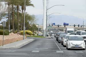
Commercial development, major power transmission lines and cars near the intersection of Eastern and Serene Avenues, looking north-northwest in Las Vegas, Nevada: digital photograph
Date
Archival Collection
Description
From the UNLV University Libraries Photographs of the Development of the Las Vegas Valley, Nevada (PH-00394). Part of the collection documents the entire 19 mile length of the north/south Eastern Avenue / Civic Center Drive alignment. This photograph was captured in the section of Eastern Avenue between Pebble Road and Silverado Ranch Boulevard.
Image
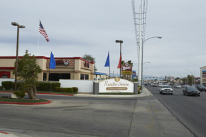
An entrance to the Rancho Serene apartments off Eastern Avenue south of Serene Avenue, looking north-northwest in Las Vegas, Nevada: digital photograph
Date
Archival Collection
Description
From the UNLV University Libraries Photographs of the Development of the Las Vegas Valley, Nevada (PH-00394). Part of the collection documents the entire 19 mile length of the north/south Eastern Avenue / Civic Center Drive alignment. This photograph was captured in the section of Eastern Avenue between Pebble Road and Silverado Ranch Boulevard.
Image
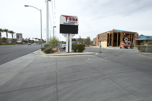
The old T-Bird lounge being converted to a Sierra Gold pub off Eastern Avenue south of Serene Avenue, looking south-southwest in Las Vegas, Nevada: digital photograph
Date
Archival Collection
Description
From the UNLV University Libraries Photographs of the Development of the Las Vegas Valley, Nevada (PH-00394). Part of the collection documents the entire 19 mile length of the north/south Eastern Avenue / Civic Center Drive alignment. This photograph was captured in the section of Eastern Avenue between Pebble Road and Silverado Ranch Boulevard.
Image
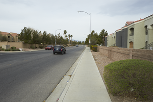
Multi-family housing lines Richmar Avenue near Eastern Avenue, looking west-southwest in Las Vegas, Nevada: digital photograph
Date
Archival Collection
Description
From the UNLV University Libraries Photographs of the Development of the Las Vegas Valley, Nevada (PH-00394). Part of the collection documents the entire 19 mile length of the north/south Eastern Avenue / Civic Center Drive alignment. This photograph was captured in the section of Eastern Avenue between Pebble Road and Silverado Ranch Boulevard.
Image