Search Results
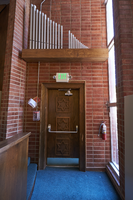
Photograph of Star of David on door of the former Temple Beth Sholom building on Oakey Blvd., Las Vegas, Nevada, May 19, 2016
Date
Archival Collection
Description
Artifacts from the building's former use as Temple Beth Sholom, like this door adorned with the Star of David, are few as the building at 1600 E. Oakey Boulevard now houses the Innovations International Charter School of Nevada.
Image
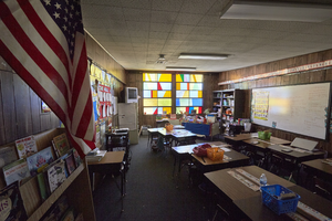
Photograph of Stain glass windows at the former Temple Beth Sholom building on Oakey Blvd., Las Vegas, Nevada, May 19, 2016
Date
Archival Collection
Description
A room at the former Temple Beth Sholom facility at 1600 E. Oakey Boulevard now serve as a classroom for the Innovations International Charter School of Nevada. They are still adorned with the original stain glass windows.
Image
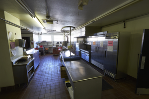
Photograph of "Faye's Kitchen" at former Temple Beth Sholom building on Oakey Blvd., Las Vegas, Nevada, May 19, 2016
Date
Archival Collection
Description
Dubbed "Faye's Kitchen," the cooking facility at the former Temple Beth Sholom at 1600 E. Oakey Boulevard now serves students at the Innovations International Charter School of Nevada. "Faye" refers to Faye Steinberg.
Image

Negatives of Senator Bob Kerrey visiting the Frontier Strike, Culinary Union, Las Vegas (Nev.), 1990s (folder 1 of 1)
Date
Archival Collection
Description
Arrangement note: Series I. Demonstrations, Subseries I.A. Frontier Strike
Image
Photographs of Jim Arnold, George Williams, and Joe Tudaro election party, Culinary Union, Las Vegas (Nev.), 1987 (folder 4 of 4)
Date
Archival Collection
Description
Arrangement note: Series III. Internal: Work
Image
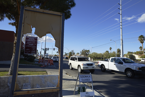
A damaged sign along Eastern Avenue near Hacienda Avenue, looking south in Las Vegas, Nevada: digital photograph
Date
Archival Collection
Description
From the UNLV University Libraries Photographs of the Development of the Las Vegas Valley, Nevada (PH-00394). Part of the collection documents the entire 19 mile length of the north/south Eastern Avenue / Civic Center Drive alignment. This photograph was captured in the section of Eastern Avenue between Tropicana Avenue and Russell Road.
Image
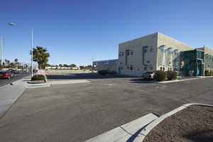
A commercial building on Eastern Avenue near Hacienda Avenue, looking north-northeast in Las Vegas, Nevada: digital photograph
Date
Archival Collection
Description
From the UNLV University Libraries Photographs of the Development of the Las Vegas Valley, Nevada (PH-00394). Part of the collection documents the entire 19 mile length of the north/south Eastern Avenue / Civic Center Drive alignment. This photograph was captured in the section of Eastern Avenue between Tropicana Avenue and Russell Road.
Image
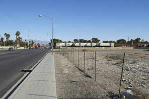
A vacant lot on Eastern Avenue north of Hacienda Avenue, looking north in Las Vegas, Nevada: digital photograph
Date
Archival Collection
Description
From the UNLV University Libraries Photographs of the Development of the Las Vegas Valley, Nevada (PH-00394). Part of the collection documents the entire 19 mile length of the north/south Eastern Avenue / Civic Center Drive alignment. This photograph was captured in the section of Eastern Avenue between Tropicana Avenue and Russell Road.
Image
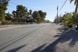
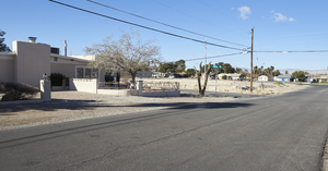
A single family home neighborhood with rural roads on Casey Drive near Eastern Avenue, looking east-northeast in Las Vegas, Nevada: digital photograph
Date
Archival Collection
Description
From the UNLV University Libraries Photographs of the Development of the Las Vegas Valley, Nevada (PH-00394). Part of the collection documents the entire 19 mile length of the north/south Eastern Avenue / Civic Center Drive alignment. This photograph was captured in the section of Eastern Avenue between Tropicana Avenue and Russell Road.
Image
A single family home in a neighborhood with rural roads on Casey Drive near Eastern Avenue, looking southwest in Las Vegas, Nevada: digital photograph
Date
Archival Collection
Description
From the UNLV University Libraries Photographs of the Development of the Las Vegas Valley, Nevada (PH-00394). Part of the collection documents the entire 19 mile length of the north/south Eastern Avenue / Civic Center Drive alignment. This photograph was captured in the section of Eastern Avenue between Tropicana Avenue and Russell Road.
Image