Search the Special Collections and Archives Portal
Search Results
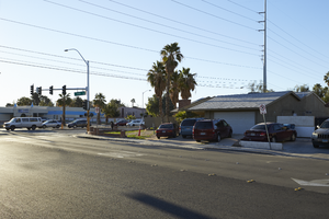
A residential area bounded by Reno and Eastern Avenues near Tropicana Avenue, looking east-southeast in Las Vegas, Nevada: digital photograph
Date
Archival Collection
Description
From the UNLV University Libraries Photographs of the Development of the Las Vegas Valley, Nevada (PH-00394). Part of the collection documents the entire 19 mile length of the north/south Eastern Avenue / Civic Center Drive alignment. This photograph was captured in the section of Eastern Avenue between Tropicana Avenue and Russell Road.
Image
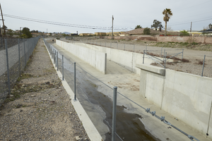
The Pittman Pecos Conveyance as seen from Serene Avenue east of Eastern Avenue, looking south-southeast in Henderson, Nevada: digital photograph
Date
Archival Collection
Description
From the UNLV University Libraries Photographs of the Development of the Las Vegas Valley, Nevada (PH-00394). Part of the collection documents the entire 19 mile length of the north/south Eastern Avenue / Civic Center Drive alignment. This photograph was captured in the section of Eastern Avenue between Pebble Road and Silverado Ranch Boulevard.
Image
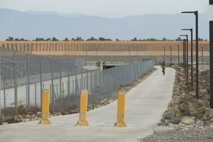
The Cactus Wren Trail as seen from Serene Avenue east of Eastern Avenue, looking north-northwest in Henderson, Nevada: digital photograph
Date
Archival Collection
Description
From the UNLV University Libraries Photographs of the Development of the Las Vegas Valley, Nevada (PH-00394). Part of the collection documents the entire 19 mile length of the north/south Eastern Avenue / Civic Center Drive alignment. This photograph was captured in the section of Eastern Avenue between Pebble Road and Silverado Ranch Boulevard.
Image

Signage for a Southwest Medical facility on Eastern Avenue near Russell Road, looking east-southeast in Las Vegas, Nevada: digital photograph
Date
Archival Collection
Description
From the UNLV University Libraries Photographs of the Development of the Las Vegas Valley, Nevada (PH-00394). Part of the collection documents the entire 19 mile length of the north/south Eastern Avenue / Civic Center Drive alignment. This photograph was captured in the section of Eastern Avenue between Russell and Sunset Roads.
Image
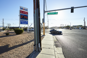
A Mobil gas station sign on the corner of Eastern Avenue and Warm Springs Road, looking east in Las Vegas, Nevada: digital photograph
Date
Archival Collection
Description
From the UNLV University Libraries Photographs of the Development of the Las Vegas Valley, Nevada (PH-00394). Part of the collection documents the entire 19 mile length of the north/south Eastern Avenue / Civic Center Drive alignment. This photograph was captured in the section of Eastern Avenue between Sunset and Warm Springs Roads.
Image
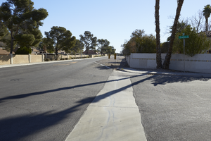
A single family home neighborhood on Reno Avenue near Eastern Avenue, looking east-northeast in Las Vegas, Nevada: digital photograph
Date
Archival Collection
Description
From the UNLV University Libraries Photographs of the Development of the Las Vegas Valley, Nevada (PH-00394). Part of the collection documents the entire 19 mile length of the north/south Eastern Avenue / Civic Center Drive alignment. This photograph was captured in the section of Eastern Avenue between Tropicana Avenue and Russell Road.
Image
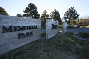
Davis Funeral Home and Memorial Park on Eastern Avenue south of Patrick Lane, looking east in Las Vegas, Nevada: digital photograph
Date
Archival Collection
Description
From the UNLV University Libraries Photographs of the Development of the Las Vegas Valley, Nevada (PH-00394). Part of the collection documents the entire 19 mile length of the north/south Eastern Avenue / Civic Center Drive alignment. This photograph was captured in the section of Eastern Avenue between Russell and Sunset Roads.
Image
Compilation of Selected Hydrologic Data from the MX Missile-Siting Investigation, East-Central Nevada and Western Utah, Open File Report, 1984
Level of Description
Archival Collection
Collection Name: David Donovan Collection on Hydrology and Geology
Box/Folder: Box 61
Archival Component
U.S. Playing Card Co., Union-Castle Line Royal Mail Steamers between England, South Africa, and East Africa, approximately 1919
Level of Description
Archival Collection
Collection Name: Harrah’s Entertainment Corporate Archives
Box/Folder: Box 99 (Restrictions apply)
Archival Component
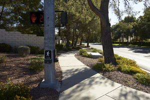
Sidewaks, traffic light, and landscaping on the corner of Fort Apache Road and Lake North Drive, looking east, Las Vegas, Nevada: digital photograph
Date
Archival Collection
Description
Image
