Search Results
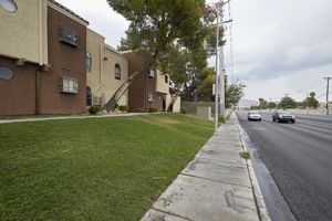
Grass landscaping at the Pacific Harbors Sunrise Apartments on East Sahara Avenue near Nellis Boulevard, Clark County, Nevada: digital photograph
Date
2017-09-08
Archival Collection
Description
Grass landscaping in front of the Pacific Harbors Sunrise Apartments on East Sahara Avenue just east of Nellis Boulevard.
Image
T-Shirt Color: Gray; Front: East Haven Firefighters Local 1205, Local Union Emblem; Handwritten Text: God Bless All Of The Fallen , East Haven CT. 14, Feb. 2002, approximately 2001-2012
Level of Description
File
Archival Collection
New York-New York Hotel and Casino 9-11 Heroes Tribute Collection
To request this item in person:
Collection Number: MS-00459
Collection Name: New York-New York Hotel and Casino 9-11 Heroes Tribute Collection
Box/Folder: Box 343
Collection Name: New York-New York Hotel and Casino 9-11 Heroes Tribute Collection
Box/Folder: Box 343
Archival Component
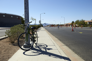
Bicycle on Tree Line Drive north of East Sahara Avenue, looking south, Las Vegas, Nevada: digital photograph
Date
2017-09-28
Archival Collection
Description
A bicycle is locked to a light pole along Tree Line Drive north of East Sahara Avenue next to Las Vegas High School.
Image
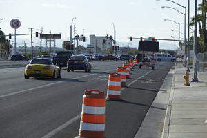
Traffic barrels on Fremont Street near East Sahara Avenue looking southeast, Las Vegas, Nevada: digital photograph
Date
2017-09-14
Archival Collection
Description
Traffic barrels mark a construction area on Fremont Street northwest of East Sahara Avenue. Fremont Street turns into Boulder Highway the intersection
Image
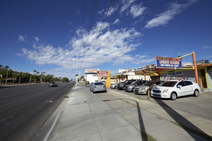
Sahara Auto on East Sahara Avenue near Chapman Drive looking west, Las Vegas, Nevada: digital photograph
Date
2017-09-13
Archival Collection
Description
Sahara Auto used car sales lot sits on East Sahara Avenue between of Chapman Drive and South 17th Street.
Image

Business on South Santa Clara Drive at East Sahara Avenue looking south, Las Vegas, Nevada: digital photograph
Date
2017-09-12
Archival Collection
Description
The Record City business sits at South Santa Clara Drive and East Sahara Avenue. Turnberry Towers can be seen ing the background.
Image
RTC bus stop on East Sahara Avenue near Joe W Brown Drive looking west, Las Vegas, Nevada: digital photograph
Date
2017-09-12
Archival Collection
Description
Traffic flows on East Sahara Avenue near an RTC Sahara Express bus stop east of Joe W Brown Drive.
Image

Drag show at the Kit Kat Club, located at 2501 East Charleston Boulevard, Las Vegas, Nevada: digital image
Date
1943 to 1944
Archival Collection
Description
From the Dennis McBride Photograph Collection (PH-00263) -- LGBTQ+ events and organizations in Las Vegas, Nevada -- Digital images file. Notes from the donor, Dennis McBride: The address given for the Kit Kat Club is approximate as it stood on the outskirts of Las Vegas at what then was known as "Five Points": the intersection of East Charleston Boulevard, East Fremont Street, and the Boulder Highway [at this location today noted as the extension of East Fremont Street]. ... This photograph belongs to the Clark County Museum. ... For more on the Kit Kat Club, see Out of the Neon Closet: Queer Community in the Silver State, by Dennis McBride [North Charleston, South Carolina: CreateSpace Independent Publishing Platform], p. 56. Individuals identified by the donor, Dennis McBride: unidentified female impersonator
Image