Search Results
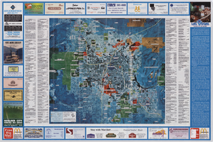
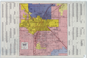
Aerial map of the Las Vegas Valley, with map of Las Vegas, 1992
Date
Description
Image
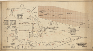
Map showing proposed improvements of Las Vegas Springs, Las Vegas, Nevada, January 26, 1918
Date
Archival Collection
Description
'Exhibit A'. 'Approved Jan. 26, 1918.' Includes discharge figures and plans for improvements to springs for the municipal water system including diagrams of spillway openings, etc. Scale [ca. 1:1200] 1 in.=100 feet -- Scale [ca. 1:120] 1 in.=10 feet -- Scale [ca. 1:240] 1 in.=20 feet -- Scale [ca. 1:24] 1 in.=2 feet -- Scale [ca. 1:2400] 1 in.=200 feet. Vertical scale [ca. 1:48] 1 in.=4 feet -- Scale [ca. 1:12] 1 in.=1 foot.
Image
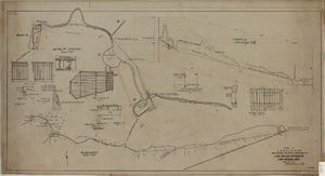
Map showing proposed improvement of Las Vegas Springs, Las Vegas, Nevada, September 21, 1916
Date
Description
'Exhibit A'. 'Approved Sept. 21, 1916.' 'W.E.J.'"--Lower left corner. 'L-44-50 to 61. T-75 - 17 & 46'--Upper left corner. Includes discharge figures and plans for improvements to springs Scale [ca. 1:240]. 1 in. to 20 feet. -- Scale [ca. 1:2,400]. 1 in. to 200 ft. Vertical scale [ca. 1:48]. 1 in. to 4 feet. -- Scale [ca. 1:4,800]. 1 in. to 100 feet. Library's copy has "Proposed layout" written on it in pencil near lower center and other markings in red. Contents: Detail at springs -- Profile -- Alignment.
Image
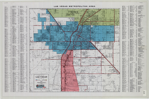
Maps of Las Vegas metropolitan area, Grand Canyon National Park and national parks near Las Vegas, Nevada, 2008
Date
Description
Text
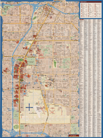
A general map of Las Vegas, 1969
Date
Description
Image
Lalli, Sergio. Casino Raid: IRS Agents Snatch Dealer's Toke Boxes, Hotel and Motel Management 203(3), 1988 February 22
Level of Description
Archival Collection
Collection Name: UNLV Libraries Collection of Articles on Gaming and Las Vegas, Nevada Topics
Box/Folder: Box 06
Archival Component

Topographic map of Nevada-California, Las Vegas quadrangle, March 1908
Date
Description
Text
General map of Las Vegas, Nevada, June 1962
Date
Description
Text
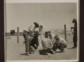
Cowboys at Walking Box Ranch, Nevada branding cattle. Rex Bell (George Francis Beldam) is second from the left: photographic print
Date
Archival Collection
Description
Bell Family Scrapbook scanning, Set 2, proofed 08.04.2010
Image
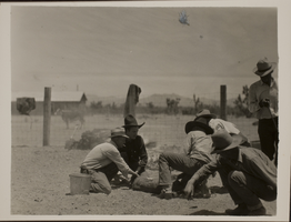
Cowboys at Walking Box Ranch, Nevada branding cattle. Rex Bell (George Francis Beldam) is second from the left: photographic print
Date
Archival Collection
Description
Bell Family Scrapbook scanning, Set 2, proofed 08.04.2010
Image