Search Results
Richard Box, #14, University of Nevada, Las Vegas basketball player, 1978-1979
Level of Description
File
Archival Collection
University of Nevada, Las Vegas Creative Services Thematic Slides and Prints
To request this item in person:
Collection Number: PH-00388-06
Collection Name: University of Nevada, Las Vegas Creative Services Thematic Slides and Prints
Box/Folder: Box 110
Collection Name: University of Nevada, Las Vegas Creative Services Thematic Slides and Prints
Box/Folder: Box 110
Archival Component
Richard Box, #14, University of Nevada, Las Vegas basketball player, 1979-1980
Level of Description
File
Archival Collection
University of Nevada, Las Vegas Creative Services Thematic Slides and Prints
To request this item in person:
Collection Number: PH-00388-06
Collection Name: University of Nevada, Las Vegas Creative Services Thematic Slides and Prints
Box/Folder: Box 111
Collection Name: University of Nevada, Las Vegas Creative Services Thematic Slides and Prints
Box/Folder: Box 111
Archival Component

Official Arrow city map, Las Vegas & vicinity, Nevada, circa 1957-1961
Date
1957 to 1961
Description
71 x 68 cm. on sheet 106 x 71 cm., folded in cover 25 x 12 cm. Cover title: Latest edition, city map and street index of "fabulous" Las Vegas and vicinity, Nevada. Publisher from cover. "H-654-32." Includes indexes. Inside of cover includes information on Las Vegas. Includes inset maps of Boulder City, Nevada, and Las Vegas's location. Original publisher: R. L. Polk.
Image
Las Vegas boxing match (x22904): 35mm slides, 1977 to 1980
Level of Description
File
Archival Collection
Hank deLespinasse Photographs
To request this item in person:
Collection Number: PH-00454
Collection Name: Hank deLespinasse Photographs
Box/Folder: Box 23
Collection Name: Hank deLespinasse Photographs
Box/Folder: Box 23
Archival Component
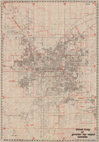
Street map of greater Las Vegas, Nevada, 1984
Date
1984
Description
'The professional street map of greater Las Vegas, Nevada. Detailed guide of Las Vegas, North Las Vegas, Paradise Valley & vicinity' -- front panel. ' Street index on map verso. Original publisher: Front Boy Service Co. Scale [ca. 1:44,352. 1 in. to approx. 0.70 mi.].
Text
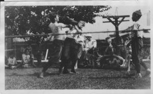
Unknown group of boys boxing: photographic print
Date
1880 to 1979
Archival Collection
Description
Dorothy Bell Scans UNLV-Public Lands Institute
Image

Map of the city of Las Vegas, Nevada, June 1, 1946
Date
1946-06-01
Description
Scale [ca. 1:9,600. 1 in. to approx. 800 ft.]. Cadastral map. 'Compiled by Pioneer Title Insurance &Trust Company.' 'By Jack Asher, State Nev. Reg. Engr. No. 305.' 'Issue 5, 6/1/46.' Includes indexes. Pioneer Title Insurance &Trust Company
Image
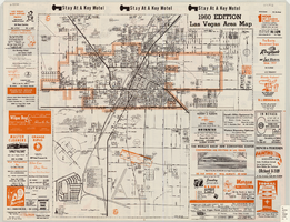
Las Vegas area map, 1960
Date
1960
Description
1960 ed. Scale [ca. 1:47,520. 1 in. equals approx. 0.75 miles.] 1 map : col. ; 41 x 43 cm., folded to 22 x 10 cm. Panel title: Welcome map : greater Las Vegas area and scenic routes to and from there. "1960-61 edition."--Panel. Irregularly-shaped map. Includes list of Las Vegas schools, inset maps of East Las Vegas (Whitney) and Wherry housing area on Nellis Air Force Base and advertisements for Las Vegas businesses. Index, mileages from cities in the United States to Las Vegas and sightseeing information on verso. Library's copy 1 has some art work and some lettering in orange and has "Las Vegas Nevada Chamber of Commerce" stamped in purple on panel. Library's copy 2 has some art work and some lettering in purple and has "Pioneer Title Insurance Co. of Nevada" stamped in black on panel. Nevada State Motel Association?
Text
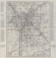
Street map of greater Las Vegas, 1963
Date
1963
Description
55 x 44 cm. Panel title: Front Boy's official 1963-1964 edition street map : detailed guide of North Las Vegas, Las Vegas, Paradise Valley and vicinity. Relief shown by spot heights. Originally folded to: 29 x 12 cm. "Note, revised and recorded 1st - 1961, 2nd - 1962, 3rd 1963, 4th - 1963."On verso: "MAR 1964" stamped in red ink on upper right hand corner. Includes notes and quotations. Includes indexes. Original publisher: Front.
Image

Map of city of Las Vegas, Nevada, October 1, 1940
Date
1940-10-01
Description
'Compiled by C.D. Baker, Oct. 1, 1940.' Scale [ca. 1:11,400]. 1 in. to 950 ft. Cadastral map.
Image