Search the Special Collections and Archives Portal
Search Results
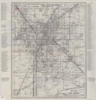
Street map of greater Las Vegas, 1963
Date
1963
Description
55 x 44 cm. Panel title: Front Boy's official 1963-1964 edition street map : detailed guide of North Las Vegas, Las Vegas, Paradise Valley and vicinity. Relief shown by spot heights. Originally folded to: 29 x 12 cm. "Note, revised and recorded 1st - 1961, 2nd - 1962, 3rd 1963, 4th - 1963."On verso: "MAR 1964" stamped in red ink on upper right hand corner. Includes notes and quotations. Includes indexes. Original publisher: Front.
Image

Map of city of Las Vegas, Nevada, October 1, 1940
Date
1940-10-01
Description
'Compiled by C.D. Baker, Oct. 1, 1940.' Scale [ca. 1:11,400]. 1 in. to 950 ft. Cadastral map.
Image
July 1910 statement, uncollected accounts, Las Vegas Land and Water Company, 1910 July
Level of Description
File
Archival Collection
San Pedro, Los Angeles & Salt Lake Railroad Company Records
To request this item in person:
Collection Number: MS-00007
Collection Name: San Pedro, Los Angeles & Salt Lake Railroad Company Records
Box/Folder: Box 01
Collection Name: San Pedro, Los Angeles & Salt Lake Railroad Company Records
Box/Folder: Box 01
Archival Component
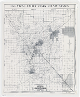
Map of Las Vegas Valley, Clark County, Nevada, 1954
Date
1954
Description
Scale [ca. 1:63,360. 1 in. to approx. 5,280 ft.].Cadastral map. 'Compiled for C.D. Baker, Reg. Civil Engineer Nevada No. 6 and Licensed Real Estate Broker by Tyson Engineering Co., Las Vegas, Nevada.' 'Copyright 1954 Tyson Engineering Co., Las Vegas, Nevada. Drawn by E.M. Ballinger' Tyson Engineering Company
Image

Film transparency of downtown Las Vegas, July 17, 1945
Date
1945-07-17
Archival Collection
Description
Black and white image of downtown Las Vegas, looking east from the corner of Fremont and Main Streets. Site Name: Fremont Street (Las Vegas, Nev.)
Image
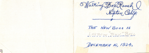
Reverse of postcard: Walking Box Ranch, Nipton, California
Date
1934-12-16
Archival Collection
Description
From the Walking Box Ranch Photograph Collection (PH-00346). "Walking Box Ranch, Nipton, Calif. The new boss is Larbow 'Tony' Bell. December 16, 1934." is written on the postcard.
Text
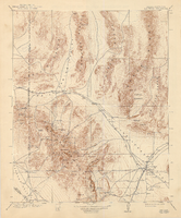
Topographic map of the Las Vegas Valley and surrounding northern and western mountain ranges, 1943
Date
1943
Description
'Edition of Mar. 1908, reprinted 1943.' 'E.M. Douglas, Geographer in charge. Topography and triangulation by R.H. Chapman, B.D. Stewart, J.E. Blackburn and D.F.C. Moor. Surveyed in 1906-1907.' Scale 1:250,000 ; polyconic proj. (W 116°00´--W 115°00´/N 37°00´--N 36°00´). Relief shown by contours and spot heights. 'Contour interval 100 feet.' 'Datum is mean sea level.' Includes township and range lines. Text and illustrations from the Topographic maps of the United States series on verso. Series: The topograhic maps of the United States. Map includes the Desert Range; Sheep Range; Pintwater Range; Las Vegas Range; Spring Mountains; Indian Springs Valley; Spotted Range. United States, Dept. of the Interior, Geological Survey
Text

Blueprint map showing proposed changes to water system, Las Vegas Land & Water Co., Las Vegas, Nevada, circa 1936
Date
1931 to 1941
Archival Collection
Description
'U.P.C. Co. #1799.31-T3-L3.'
Image
Pagination
Refine my results
Content Type
Creator or Contributor
Subject
Archival Collection
Digital Project
Resource Type
Year
Material Type
Place
Language
Records Classification

