Search Results
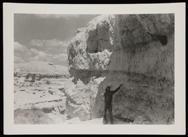
Photograph of Bob Owens at the Lost City, Valley of Fire, circa 1933
Date
1932 to 1934
Archival Collection
Description
Bob Owens looking at bees in Valley of Fire. (He had a ranch northwest of Las Vegas and later became sheriff.) (Credit: W.A. Davis; he says the location is 3-4 miles northwest of Las Vegas.)
Image
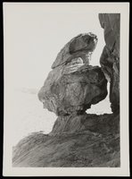
Photograph of Adeline Rock, Lost City (Nev.), May 14, 1933
Date
1933-05-14
Archival Collection
Description
Adeline Rock at Valley of Fire, May 14, 1933.
Image
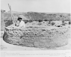
Film transparency of kiva at the Lost City near St. Thomas, Nevada, May 13, 1934
Date
1934-05-13
Archival Collection
Description
Black and white image with the following printed description: Restored kiva or underground ceremonial chamber at Lost City (Pueblo Escondido), near St. Thomas, Nevada.
Image
Lost City Museum #1: Betacam tape, approximately 1995 April 28
Level of Description
Item
Archival Collection
William Mors Audiovisual Collection
Archival Component
Lost City Museum #2: Betacam tape, approximately 1995 April 28
Level of Description
Item
Archival Collection
William Mors Audiovisual Collection
Archival Component
Lost City Museum #3: Betacam tape, approximately 1995 April 28
Level of Description
Item
Archival Collection
William Mors Audiovisual Collection
Archival Component
Discover NV Lost City: VHS videotape, approximately 1995 to 1996
Level of Description
Item
Archival Collection
William Mors Audiovisual Collection
Archival Component
Painting of the Lost City, Nevada: photographic print, approximately 1935 to 1959
Level of Description
Item
Archival Collection
UNLV Libraries Single Item Accession Photograph Collection
Archival Component
View of Lost City, Nevada: photographic print, approximately 1930 to 1959
Level of Description
Item
Archival Collection
UNLV Libraries Single Item Accession Photograph Collection
Archival Component