Search Results
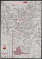
Map of metropolitan Las Vegas, Nevada, 1971
Date
Description
Text

Topographic map of Nevada-California, Las Vegas quadrangle, 1951
Date
Description
Image
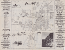
Street map of the city of Las Vegas, North Las Vegas, the "Strip", 1955
Date
Description
Image

Map showing location of the Las Vegas & Tonopah Railroad from Las Vegas to Bullfrog, Nevada, 1906
Date
Archival Collection
Description
Image
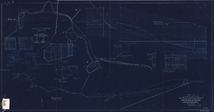
Blueprint showing proposed improvement of Las Vegas Springs, Las Vegas, Nevada, September 21, 1916
Date
Archival Collection
Description
'Exhibit A'. 'Approved Sept. 21, 1916.' '2-N-1719' handwritten in lower right corner. 'W.E.J."--Lower left corner. "L-44 - 50 to 61. T-75 - 17 & 46"--Upper left corner. Includes discharge figures and plans for improvements to springs. Scale [ca. 1:240]. 1 in. to 20 feet. -- Scale [ca. 1:2,400]. 1 in. to 200 ft. Vertical scale [ca. 1:48]. 1 in. to 4 feet. -- Scale [ca. 1:4,800]. 1 in. to 100 feet. 1 map. Contents: Detail at springs -- Profile -- Alignment.
Image

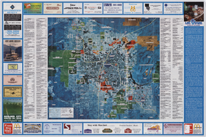
City map of Las Vegas, 1973
Date
Description
Color; 55 x 45 cm., on sheet 95 x 47 cm., folded to 24 x 10 cm. Panel title: Las Vegas city map. Copyright held by Cardinal Publishing Company. Relief shown by hachures. Includes illustrations and advertisements. Index, text, illustrations, advertisements, and map of "Lake Mead National Recreation Area, lower basin section" on verso. Original publisher: Cardinal Publishing Company.
Image
Aerial map of the Las Vegas Valley, with map of Las Vegas, 1992
Date
Description
Image
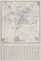
Street map of Las Vegas and vicinity, 1960
Date
Description
43 x 40 cm., folded to 18 x 9 cm. Panel title: Las Vegas and vicinity map. Includes index. Text with facts about Las Vegas, photographs of Las Vegas and nearby tourist attractions and maps of Henderson, Boulder City and downtown Las Vegas on verso. Library's copy 2 has notes handwritten in black ink. Original publisher: Thomas Bros. Maps.
Image
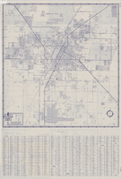
Street map of Las Vegas and vicinity, 1962
Date
Description
43 x 40 cm., folded to 18 x 9 cm. Panel title: Las Vegas and vicinity. "Richfield" below title." Includes index. Text with facts about Las Vegas, photographs of Las Vegas and nearby tourist attractions and maps of Henderson, Boulder City and downtown Las Vegas on verso. Original publisher: Thomas Bros. Maps, Scale: One inch equals approximately 0.68 mile.
Image
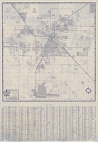
Street map of Las Vegas and vicinity, 1961
Date
Description
43 x 40 cm., folded to 18 x 9 cm. Panel title: Las Vegas and vicinity map. Includes index. Text with facts about Las Vegas, photographs of Las Vegas and nearby tourist attractions and maps of Henderson, Boulder City and downtown Las Vegas on verso. Library's copy 2 has notes handwritten in black ink. Original publisher: Thomas Bros. Maps, Scale: One inch equals approximately 0.68 mile.
Image