Search Results
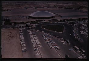
Color aerial view of the Las Vegas Convention Center.
Date
Description
Image
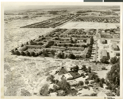
Aerial photograph of apartments and residential neighborhoods in North Las Vegas, Nevada, June 5, 1973
Date
Archival Collection
Description
Image
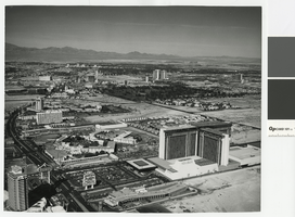
Aerial photograph of the Las Vegas Strip, circa mid 1970s
Date
Archival Collection
Description
Aerial view of the Las Vegas Strip, looking north from the former MGM Grand, since renamed Bally's. Also shown is the former Dunes Hotel, where Bellagio now stands, as well as Caesars Palace, the Flamingo, the Sands, the Frontier, Circus Circus, the Las Vegas Hilton. In the distance is Downtown Las Vegas.
Site Name: Las Vegas Strip
Address: Las Vegas Boulevard, Las Vegas, NV
Image
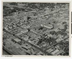
Aerial photograph of downtown Las Vegas with comments, Las Vegas (Nev.), June 23, 1962
Date
Archival Collection
Description
Mixed Content
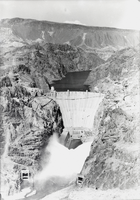
Film transparency of an aerial view of open valves, Hoover Dam, circa mid 1930s
Date
Archival Collection
Description
Image

Slide of an aerial view of the Las Vegas Strip, circa 1990s-2000s
Date
Archival Collection
Description
Image
Aerial b-roll footage of Las Vegas during the day: video
Date
Archival Collection
Description
B-roll aerial footage of Las Vegas area including the Landmark, Tropicana, Sands, Desert Inn, El Rancho, and Sahara hotels. Original media U-matic S, color, aspect ratio 4 x 3, frame size 720 x 486. From The Production Company Audiovisual Collection (MS-00930) -- Digitized audiovisual material file.
Moving Image
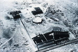
Slide of aerial view of University of Nevada, Las Vegas campus, circa 1963-1966
Date
Archival Collection
Description
Image
Las Vegas diagrammed aerial by Cooper Aerial Surveys Co. (scaled at 1 inch = 2,000 feet): photographic print, 1976 June 04
Level of Description
Archival Collection
Collection Name: UNLV University Libraries Collection of Aerial Photographs
Box/Folder: Flat File 02
Archival Component
Las Vegas diagrammed aerial by Cooper Aerial Surveys Co. (scaled at 1 inch = 2,000 feet): photographic print, 1978 February 22
Level of Description
Archival Collection
Collection Name: UNLV University Libraries Collection of Aerial Photographs
Box/Folder: Flat File 02
Archival Component