Search Results
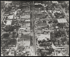
Photograph of an aerial view of Las Vegas, Las Vegas (Nev.), 1940
Date
1940
Archival Collection
Description
Aerial view of Las Vegas, Nevada from Fourth Street to Main Street (near Fremont Street), 1940
Image
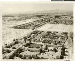
Aerial photograph of apartments and residential neighborhoods in North Las Vegas, Nevada, June 5, 1973
Date
1973-06-05
Archival Collection
Description
Aerial view of Northland Gardens apartments and surrounding neighborhoods, North Las Vegas, Nevada, looking southeast from around Geist Avenue. Sandy Lane runs from southwest to northeast through the center of the photograph. Clifford Street appears at the lower right. Caption on back of photograph: "Project: Land use, Sandy Lane, North Gardens in foreground, looking south; Americana on east side of Sandy"
Image
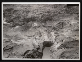
Aerial photograph of upstream face of Hoover Dam, circa 1933-1935
Date
1933 to 1935
Archival Collection
Description
An image showing an aerial view of the nearly completed Hoover Dam in Black Canyon prior to the release of water.
Image
Aerial photograph of the Sands Hotel (Las Vegas), late 1960s
Date
1967 to 1969
Archival Collection
Description
Aerial view of the Sands Hotel after the addition of the tower. Stamped on original: "Las Vegas News Bureau. Las Vegas, Nevada,Convention Center. 12844, Don English, Jerry Abbott, Joe Buck, Milt Palmer, John Cook."
Site Name: Sands Hotel
Address: 3355 Las Vegas Boulevard South
Image
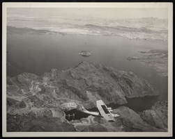
Aerial photograph of Hoover Dam, Lake Mead, Black Canyon, circa 1934-1935
Date
1934 to 1935
Archival Collection
Description
Aerial view of Hoover Dam. Seaplane (probably a Consolidated PBY Catalina Model 28 flying boat) with registry NC 777 seen flying over Black Canyon.
Image
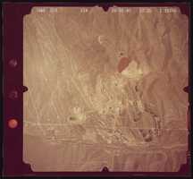
Aerial photograph of desert, Henderson (Nev.), June 5, 1980
Date
1991-10-13
Archival Collection
Description
Photograph of unidentified desert land in Henderson, NV.
Image
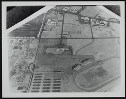
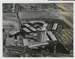
Aerial view of the Convention Center Las Vegas, Nevada: photographic print
Date
1960 (year uncertain; year approximate) to 1963 (year uncertain; year approximate)
Archival Collection
Description
From the UNLV Libraries Single Item Accession Photograph Collection (PH-00171). View of racetrack (racetrack at bottom right corner), soon after the LVCC was built.
Image
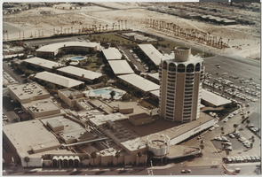
Aerial photograph of the Sands Hotel complex (Las Vegas), circa 1968
Date
1967 to 1969
Archival Collection
Description
Aerial view of the Sands complex.
Site Name: Sands Hotel
Address: 3355 Las Vegas Boulevard South
Image
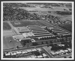
Aerial photograph of Rancho High School, North Las Vegas, Nevada, circa 1960s-1970s
Date
1960 to 1979
Archival Collection
Description
An aerial view of Rancho High School, North Las Vegas, Nevada, circa 1960s-1970s. The school is located near the intersection of Bruce Street and Owens Avenue.
Image

Aerial photograph of C. P. Squires Elementary School, North Las Vegas, Nevada, circa 1960s-1970s
Date
1960 to 1979
Archival Collection
Description
Aerial view of C. P. Squires Elementary School, North Las Vegas, Nevada, circa 1960s-1970s. The school is located near the intersection of Tonopah Avenue and McDonald Street.
Image