Search Results
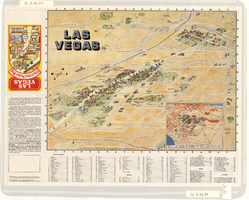
Map of the Las Vegas Strip, downtown Las Vegas and surrounding areas, 1987
Date
1987
Description
Panel title: Las Vegas illustrated pocket map. Bird's-eye view map of the Strip and downtown Las Vegas. Shows casinos, motels, golf courses, recreational vehicle parks, and other places of interest to tourists. Includes indexes. Includes text and inset map of locations of other cities and sites of interest to tourists in the surrounding states and their distances from Las Vegas. Travel Graphics International (Firm)
Text
Murphy-Farmer Family Photograph Collection
Identifier
PH-00174
Abstract
The Murphy-Farmer collection contains black-and-white photographic prints (approximately 1930-1959) depicting locations around southern Nevada, including Lake Mead, Hoover Dam, Las Vegas, and Boulder City, Nevada.
Archival Collection
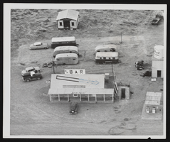
Photograph of bar grand opening, Pahrump (Nev.), September 24, 1954
Date
1954-09-24
Archival Collection
Description
Aerial photograph of bar's grand opening. Inscription with photo reads: "Cotton Pickin' Bar in Pahrump, 1954. Opened the day of the Road opening."
Image
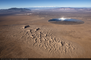
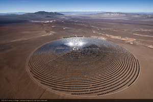
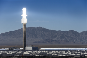
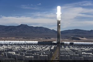
Power production and system testing at Crescent Dunes Solar, near Tonopah, Nevada: digital photograph
Date
2015-10-09
Archival Collection
Description
Photographer's note: "Aerial photograph of Crescent Dunes Solar, a 110MW tower style concentrated solar power plant with molten salt storage near Tonopah, Nevada, USA. On this day, the system was being tested by heating molten salt at the top of the glowing tower to 1050°F (566°C), then using the resultant thermal energy to drive steam turbines, which in turn sent electrical power to the Nevada grid.."
Photographer's assigned keywords: "110 megawatts; CSP; Concentrated Solar Energy; Concentrated Solar Power; Crescent Dunes; NV; Nevada; Solar Reserve; SolarReserve; Tonopah; aerial; concentrated solar thermal; green energy; molten salt; renewable energy; storage; tower."
Photographer's assigned keywords: "110 megawatts; CSP; Concentrated Solar Energy; Concentrated Solar Power; Crescent Dunes; NV; Nevada; Solar Reserve; SolarReserve; Tonopah; aerial; concentrated solar thermal; green energy; molten salt; renewable energy; storage; tower."
Image
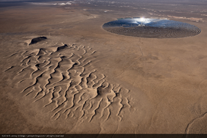

Topographic map of the southeast quadrangle of the metropolitan Las Vegas, Nevada area, 1984
Date
1984
Description
Scale 1:24,000 ; polyconic proj. (W 115°0730--W 115°0000/N 36°0730--N 36°0000) ; 1 map : col. ; 58 x 47 cm ; 7.5 minute series (topographic) ; Relief shown by contours and spot heights ; Filing title: Las Vegas SE, Nev ; "DMA 2956 II SE--Series V896." ; Contour interval 20 feet ; "Topography by photogrammetric methods from aerial photographs taken 1965. Field checked 1967." ; "Revisions shown in purple and woodland compiled from aerial photographs taken 1982 and other sources. This information not field checked. Map edited 1984." ; Includes quadrangle location map ; Interior--Geological Survey
Image