Search Results
Verna Mortensen Photograph Collection
Identifier
Abstract
The Verna Mortensen Photograph Collection (approximately 1960-1679) is comprised of eight photographic prints that depict Fremont Street in Las Vegas, Nevada and ferries on the Colorado River in Nevada.
Archival Collection
Delores Brownhofer Neonis Photograph Collection
Identifier
Abstract
The Dolores Brownhofer Neonis Photograph Collection (approximately 1940-1970) contains photographic prints, negatives, and a slide depicting the Brownhofer family at restaurants, bars, and casinos in Las Vegas, Nevada.
Archival Collection
UNLV University Libraries Photographs of the Jewish Community of Southern Nevada
Identifier
Abstract
The UNLV University Libraries Photographs of the Jewish Community of Southern Nevada (2015-2018) are comprised of digital images captured as part of the Southern Nevada Jewish Heritage Project. The photographs include members of the Southern Nevada Jewish community, synagogues Temple Beth Sholom (current and original site), Congregation Ner Tamid (including aerials), Chabad of Las Vegas, Temple Sinai, and Midbar Kodesh Temple. There are also photographs of The Desert Torah Academy's Robert Cohen Educational Campus, the future site of Chabad of Green Valley, the Holocaust Resource Center, Manpower Las Vegas’s 50th anniversary celebration, and the House of Straus.
Archival Collection
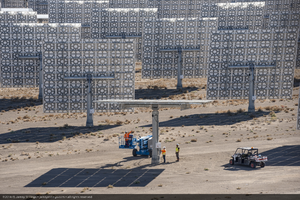
Workers adjust a heliostat at Crescent Dunes Solar, near Tonopah, Nevada: digital photograph
Date
Archival Collection
Description
Photographer's assigned keywords: "110 megawatts; CSP; Concentrated Solar Energy; Concentrated Solar Power; Crescent Dunes; NV; Nevada; Solar Reserve; SolarReserve; Tonopah; aerial; concentrated solar thermal; green energy; molten salt; on-site; renewable energy; storage; tower."
Image
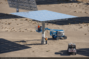

Topographic map of the northeast quadrangle of the metropolitan Las Vegas, Nevada area, 1973
Date
Description
Image

Topographic map of the northwest quadrangle of the metropolitan Las Vegas, Nevada area, 1973
Date
Description
Image

Topographic map of the southeast quadrangle of the metropolitan Las Vegas, Nevada area, 1973
Date
Description
Image

Topographic map of Cane Spring, Nevada quadrangle, 1961
Date
Description
For sale by the U.S. Geological Survey
Image
Stardust Hotel and Desert Inn Hotel Photographic Negatives
Identifier
Abstract
The Stardust Hotel and Desert Inn Hotel Photographic Negatives collection consists of black-and-white photographic negatives depicting the Stardust and Desert Inn hotels from approximately 1962 to 1967. The images depict annual and one-time events held at both hotels, including sporting events such as golf and tennis, fashion shows and beauty contests, weddings, and conventions for local and national associations. A significant amount of the collection documents the long running
Archival Collection