Search Results
Slide: Aerial view of University of Nevada, Las Vegas campus, approximately 1972-1975
Level of Description
Archival Collection
Collection Name: University of Nevada, Las Vegas Photograph Collection
Box/Folder: Binder PB-002
Archival Component
Slide: Aerial view of University of Nevada, Las Vegas campus, approximately 1972-1975
Level of Description
Archival Collection
Collection Name: University of Nevada, Las Vegas Photograph Collection
Box/Folder: Binder PB-002
Archival Component
Slide: Aerial view of University of Nevada, Las Vegas campus, approximately 1972-1975
Level of Description
Archival Collection
Collection Name: University of Nevada, Las Vegas Photograph Collection
Box/Folder: Binder PB-002
Archival Component
Slide: Aerial view of University of Nevada, Las Vegas campus, approximately 1972-1975
Level of Description
Archival Collection
Collection Name: University of Nevada, Las Vegas Photograph Collection
Box/Folder: Binder PB-002
Archival Component
Aerial view of Anderson Camp, trailer camp, and Carver Park, 1943 September 15
Level of Description
Archival Collection
Collection Name: Henderson Public Library Photograph Collection on Henderson, Nevada
Box/Folder: Folder 11
Archival Component
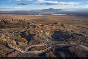
Aerial photo of the bandoned/dormant mine to the northeast of Crescent Dunes Solar, near Tonopah, Nevada: digital photograph
Date
Archival Collection
Description
Photographer's assigned keywords: "110 megawatts; CSP; Concentrated Solar Energy; Concentrated Solar Power; Crescent Dunes; NV; Nevada; Solar Reserve; SolarReserve; Tonopah; aerial; concentrated solar thermal; green energy; mine; mine near Crescent Dunes; molten salt; off-site; renewable energy; storage; tower."
Image
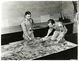
Photograph of aerial photographic map viewed by Lt Marvin R. Williams and Sgt. Erickson, circa 1940s-1950s.
Date
Archival Collection
Description
Image
Aerial photograph of the hull of the Flying Boat being towed to the Los Angeles Harbor, 1946
Date
Archival Collection
Description
Image
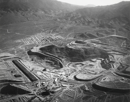
Aerial view of the Round Mountain Gold Company's mining operation in Nevada: photographic print
Date
Archival Collection
Description
From the Nye County, Nevada Photograph Collection (PH-00221) -- Series V. Smoky Valley, Nevada and Round Mountain, Nevada -- Subseries V.C. Lofthouse-Berg Families (Round Mountain). The community of Round Mountain is visible in the upper left center. The remains of Stebbins Peak can be seen on the left and Round Mountain on the right. The pit operation is visible in front of Round Mountain and Stebbins peaks. The heap leaching pads are visible as a dark wide line to the lower left of center. Looking east, Jefferson Canyon is visible in the upper center part of the pictures.
Image
Aerial view of Las Vegas Strip from the Flamingo Hotel looking north, undated
Level of Description
Archival Collection
Collection Name: Ruthe Scott Photographs of Las Vegas, Nevada Hotels and Casinos
Box/Folder: Box SH-028
Archival Component