Search Results
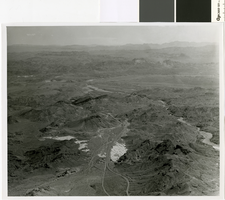
Aerial photograph of flood path, Eldorado Canyon to Nelson's Landing, September 14, 1974
Date
Archival Collection
Description
Aerial view of the path of the flood down Eldorado Canyon to Nelson's Landing.
Image
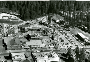
Aerial photograph of Harrah's Stateline Country Club under construction, circa 1958
Date
Archival Collection
Description
Aerial View of Harrah's Stateline Country Club under construction. The country club would later become Harrah's Tahoe.
Site Name: Harrah's Tahoe
Address: 15 Highway 50
Image
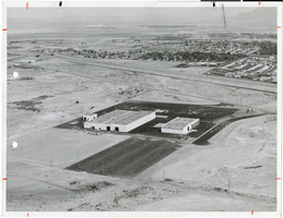
Aerial photograph of the new Edgerton, Germeshausen, and Grier facility, North Las Vegas, Nevada, April 21, 1976
Date
Archival Collection
Description
Image
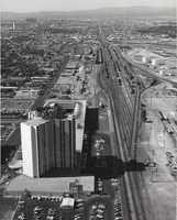
Aerial photograph of the Union Plaza Hotel and railroad tracks, Las Vegas, September 1973
Date
Archival Collection
Description
Image
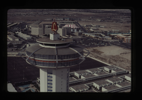
Aerial photograph of the Landmark Hotel and Circus Circus, Las Vegas, circa 1967-1972
Date
Archival Collection
Description
Image

Photograph of aerial view of mining operation, Lincoln County (Nev.), circa 1916
Date
Archival Collection
Description
Image
Russell Avery "Gypsum Cave" project aerial view, 1998
Level of Description
Archival Collection
Collection Name: Archaeo-Nevada Society Records
Box/Folder: Roll 14
Archival Component
Aerial and ground nighttime views of Bob Stupak's Vegas World property: video
Date
Archival Collection
Description
Aerial views of Bob Stupak's Vegas World but also briefly Circus Circus and The Sahara; aerial footage of Vegas World circling the property several times, and south down Las Vegas Boulevard; ground view exterior only including space themed neon signs. Original media U-matic S, color, aspect ratio 4 x 3, frame size 720 x 486. From The Production Company Audiovisual Collection (MS-00930) -- Digitized audiovisual material file.
Moving Image

Aerial photograph of the Sahara Tahoe (Stateline, Nev.), circa 1965
Date
Archival Collection
Description
Bird's-eye view of the completed Sahara Tahoe, now Horizon Casino at Stateline, Nevada.
Site Name: Sahara Tahoe
Address: US Highway 50, Stateline, NV
Image
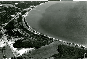
Aerial photograph of Lake Tahoe at Stateline, Nevada, circa 1958
Date
Archival Collection
Description
South shore of Lake Tahoe from the air. Harrah's Tahoe and Harvey's Tahoe are seen in the lower left corner.
Site Name: Lake Tahoe
Address: Stateline; Douglas County; Nevada
Image