Search Results
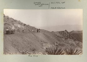
Photograph of a mine dump, Eldorado Canyon (Nev.), 1900-1925
Date
1900 to 1925
Description
Caption: (probably) Leof M. Waterhouse left/ Wm S. Mills, right Mills N. Waterhouse, Mine Dump
Image
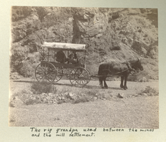
Photograph of a covered wagon on a dirt road, Eldorado Canyon (Nev.), 1900-1925
Date
1900 to 1925
Description
Caption: The rig grandpa used between the mines and the mill settlement.
Image
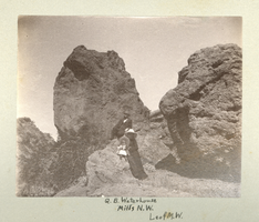
Photograph of the Mills family, Eldorado Canyon (Nev.), 1900-1925
Date
1900 to 1925
Description
Caption: G.B. Waterhouse Mills N. W. Leof M. W.
Image
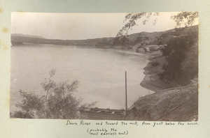
Photograph of the Colorado River from Eldorado Canyon (Nev.), 1900-1925
Date
1900 to 1925
Description
Caption: Down river and towards the mill, from just below the house. (probably the mail carrier's boat.)
Image
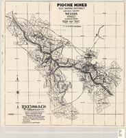
Map of the Pioche mines, Ely Mining District, Lincoln County (Nev.), 1909
Date
1909
Description
Scale unreadable ; 1 map ; 42 x 40 cm ; Photocopy. [United States ; s.n., 198-?] ; Includes township and range grid ; Includes wagon roads ;
Image
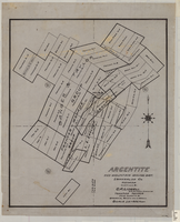
Map of Argentite: Red Mountain Mining District, Esmeralda County (Nev.),1908
Date
1908
Description
Scale [ca. 1:7,200]. 1 in. equals 600 feet ; 1 map : linen ; 46 x 39 cm
Image
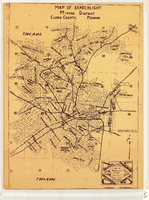
Map of Searchlight Mining District, Clark County (Nev.), 1905
Date
1905
Description
Scale not given ; 1 map ; 61 x 42 cm ; Blueline print ; Shows mineral patents and water rights ;
Image
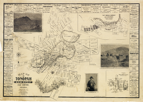
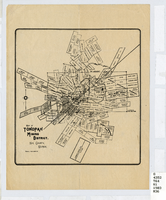
Map of the Tonopah Mining District, Nye County (Nev.), 1902
Date
1902
Description
Map of the Tonopah Mining District, Nye County (Nev.), 1902
Image
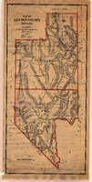
Map of Lincoln County (Nev.), 1908
Date
1908
Description
Scale [ca. 1:380,160]. 1 in. to approx. 6 miles (W 116 --W 114 /N 39 --N 35 ) ; 1 map : hand col., mounted on linen ; 115 x 54 cm ; Relief shown by hachures and spot heights ; Hand colored ; Shows range and township grid ; Shows towns, railroads, proposed railroads, wagon roads and springs ;
Image
Map of the Tonopah Mining District, Nye County (Nev.), 1903
Date
1903
Description
Scale [ca. 1:7,200]. 1 in. equals 600 feet ; 1 map ; 17 x 16 cm ; Relief shown by hachures ; Library's copy has some mines cross-hatched in pencil ;
Image