Search Results
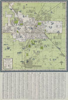
Map of Las Vegas and vicinity, 1963
Date
1963
Description
42 x 39 cm., folded to 21 x 9 cm. Panel title: Las Vegas and southern Nevada map and street guide. Includes index. Includes illustrations . Advertisement for Nevada State Bank, text with facts about Las Vegas and maps of Henderson, Boulder City and downtown Las Vegas on verso. "Courtesy of Nevada State Bank."--Panel. Original publisher: Thomas Bros. Maps.
Image
ANTENA 3 TV | Al menos 58 muertos y más de 527 heridos en un tiroteo en Las Vegas cuya autoría se atribuye Daesh: archived website, 2017
Level of Description
Other Level
Archival Collection
Web Archive on the October 1, 2017 Shooting in Las Vegas, Nevada
To request this item in person:
Collection Number: MS-00866
Collection Name: Web Archive on the October 1, 2017 Shooting in Las Vegas, Nevada
Box/Folder: N/A
Collection Name: Web Archive on the October 1, 2017 Shooting in Las Vegas, Nevada
Box/Folder: N/A
Archival Component

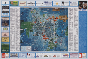
Street map of the Las Vegas area, circa 1960
Date
1959 to 1960
Description
53 x 65 cm., folded to 22 x 9 cm. Panel title: Welcome map & established guide to the greater Las Vegas area and scenic routes to and from there. Includes index and advertisements for local businesses. Las Vegas Motel Association map on verso along with advertisements, information on the Las Vegas Convention Center, and sightseeing information. Map was probably distributed by the Las Vegas Chamber of Commerce. Library's copy has freeway, service road, and streets connecting to the freeway marked with different colors of crayon and includes notes. 1960 ed. Map is irregularly shaped. Original publisher: Las Vegas Motel Association.
Image

Map of Las Vegas, Nevada, annotated to show different soil types, September 2, 1948
Date
1948-09-02
Archival Collection
Description
'Types of soil as determined by James M. Montgomery for use in appraisal. (Copy). LRM 7/10/52'--handwritten in blue pencil in lower right corner of map. 'September 2, 1947. Revised September 2, 1948.' Soil was designated as badly corrosive, mildly corrosive, or non-corrosive by hand-drawn colored lines and hand-printed labels. Soil was surveyed to measure its effect on water pipes. Scale [ca. 1:7,200] 1 in.=600 feet.
Image
Academic Advancement Programs; Academic Advising & Resources Center - Upward Bound Publications by UNLV Archives, approximately 1974 to 1994
Level of Description
File
Archival Collection
Clark County Planning Commission Research Library Collection
To request this item in person:
Collection Number: MS-01027
Collection Name: Clark County Planning Commission Research Library Collection
Box/Folder: Box 83
Collection Name: Clark County Planning Commission Research Library Collection
Box/Folder: Box 83
Archival Component
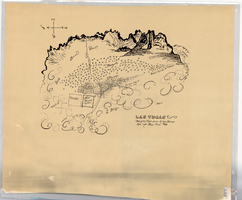
Hand-drawn map of Las Vegas, Nevada, circa 1855
Date
1850 to 1859
Description
Not drawn to scale. Relief shown pictorially. Facsimile of manuscript map. Oriented with north to left. Shows Las Vegas Mormon Fort, desert, mountains.
Image

Map showing proposed annexation of Las Vegas Valley, Clark County, Nevada, January 1, 1929
Date
1929-01-01
Description
'Compiled by C. D. Baker, C.E., United States Mineral Surveyor, State Right Water Surveyor, Nevada. Las Vegas, Nev. January 1, 1929. Copyright applied for.' ; "Filed Dec. 10, 1936" and signed by Viola Burns, clerk, city of Las Vegas ; Hand-printed title at top of map: Proposed annexation to Las Vegas ; Map is stamped as Filed Dec 10, 1936 and signed by Las Vegas City Clerk Viola Burns. Library's copy has brown line hand-drawn around area to be annexed.
Image
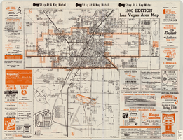
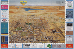
Las Vegas area map, 1960
Date
1960
Description
1960 ed. Scale [ca. 1:47,520. 1 in. equals approx. 0.75 miles.] 1 map : col. ; 41 x 43 cm., folded to 22 x 10 cm. Panel title: Welcome map : greater Las Vegas area and scenic routes to and from there. "1960-61 edition."--Panel. Irregularly-shaped map. Includes list of Las Vegas schools, inset maps of East Las Vegas (Whitney) and Wherry housing area on Nellis Air Force Base and advertisements for Las Vegas businesses. Index, mileages from cities in the United States to Las Vegas and sightseeing information on verso. Library's copy 1 has some art work and some lettering in orange and has "Las Vegas Nevada Chamber of Commerce" stamped in purple on panel. Library's copy 2 has some art work and some lettering in purple and has "Pioneer Title Insurance Co. of Nevada" stamped in black on panel. Nevada State Motel Association?
Text