Search Results
Harvey's Gaming Archives and Displays: GCHK 6001-7200, Gaming Checks Master Collection, undated
Level of Description
File
Archival Collection
Harvey's Lake Tahoe Hotel and Casino Collection
To request this item in person:
Collection Number: MS-00475
Collection Name: Harvey's Lake Tahoe Hotel and Casino Collection
Box/Folder: Box 10
Collection Name: Harvey's Lake Tahoe Hotel and Casino Collection
Box/Folder: Box 10
Archival Component
Harvey's Gaming Archives and Displays: GCHK 7201-8400, Gaming Checks Master Collection, undated
Level of Description
File
Archival Collection
Harvey's Lake Tahoe Hotel and Casino Collection
To request this item in person:
Collection Number: MS-00475
Collection Name: Harvey's Lake Tahoe Hotel and Casino Collection
Box/Folder: Box 10
Collection Name: Harvey's Lake Tahoe Hotel and Casino Collection
Box/Folder: Box 10
Archival Component
Harvey's Gaming Archives and Displays: GCHK 8401-13800, Gaming Checks Master Collection, undated
Level of Description
File
Archival Collection
Harvey's Lake Tahoe Hotel and Casino Collection
To request this item in person:
Collection Number: MS-00475
Collection Name: Harvey's Lake Tahoe Hotel and Casino Collection
Box/Folder: Box 11
Collection Name: Harvey's Lake Tahoe Hotel and Casino Collection
Box/Folder: Box 11
Archival Component
Harvey's Gaming Archives and Displays: GCHK 13801-14640, Gaming Checks Master Collection, undated
Level of Description
File
Archival Collection
Harvey's Lake Tahoe Hotel and Casino Collection
To request this item in person:
Collection Number: MS-00475
Collection Name: Harvey's Lake Tahoe Hotel and Casino Collection
Box/Folder: Box 11
Collection Name: Harvey's Lake Tahoe Hotel and Casino Collection
Box/Folder: Box 11
Archival Component
Harvey's Gaming Archives and Displays: GCHK 14641-15600, Gaming Checks Master Collection, undated
Level of Description
File
Archival Collection
Harvey's Lake Tahoe Hotel and Casino Collection
To request this item in person:
Collection Number: MS-00475
Collection Name: Harvey's Lake Tahoe Hotel and Casino Collection
Box/Folder: Box 11
Collection Name: Harvey's Lake Tahoe Hotel and Casino Collection
Box/Folder: Box 11
Archival Component
Archives committee working files, Kae de Brent Hodges working files, 1960 to 1989
Level of Description
File
Archival Collection
International Food Service Executives Association Records
To request this item in person:
Collection Number: MS-00305
Collection Name: International Food Service Executives Association Records
Box/Folder: Box 157 (Restrictions apply)
Collection Name: International Food Service Executives Association Records
Box/Folder: Box 157 (Restrictions apply)
Archival Component
Harvey's Gaming Archives and Displays: GCHK 1201-2400, Gaming Checks Master Collection, undated
Level of Description
File
Archival Collection
Harvey's Lake Tahoe Hotel and Casino Collection
To request this item in person:
Collection Number: MS-00475
Collection Name: Harvey's Lake Tahoe Hotel and Casino Collection
Box/Folder: Box 08, Box 09
Collection Name: Harvey's Lake Tahoe Hotel and Casino Collection
Box/Folder: Box 08, Box 09
Archival Component
Harvey's Gaming Archives and Displays: GCHK 15601-16208, Gaming Checks Master Collection, undated
Level of Description
File
Archival Collection
Harvey's Lake Tahoe Hotel and Casino Collection
To request this item in person:
Collection Number: MS-00475
Collection Name: Harvey's Lake Tahoe Hotel and Casino Collection
Box/Folder: Box 11, Box 12
Collection Name: Harvey's Lake Tahoe Hotel and Casino Collection
Box/Folder: Box 11, Box 12
Archival Component
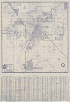
Street map of Las Vegas and vicinity, 1961
Date
1961
Description
43 x 40 cm., folded to 18 x 9 cm. Panel title: Las Vegas and vicinity map. Includes index. Text with facts about Las Vegas, photographs of Las Vegas and nearby tourist attractions and maps of Henderson, Boulder City and downtown Las Vegas on verso. Library's copy 2 has notes handwritten in black ink. Original publisher: Thomas Bros. Maps, Scale: One inch equals approximately 0.68 mile.
Image

Topographic map of Nevada-California, Las Vegas quadrangle, March 1908
Date
1908-03
Description
'Edition of Mar. 1908.' 'E.M. Douglas, geographer in charge; Topography and triangulation by R.H. Chapman, B.D. Stewart, J.E. Blackburn, and D.F.C. Moor. Surveyed in 1906-1907.' Scale 1:250,000 (W 116°00--W 115°00/N 37°00--N 36°00). Relief shown by contours and spot heights. Title in lower-right corner: Las Vegas. Contour interval 100 feet. Datum is mean sea level. "Topography"--Center of top margin. Text about the Topographic Maps of the United States series and symbols used on map on verso. U.S. Geological Survey
Text